Approximate Location Map
Large Map »
Latitude: 52.9573 / 52°57'26"N
Longitude: -3.9767 / 3°58'36"W
OS Eastings: 267313
OS Northings: 341822
OS Grid: SH673418
Mapcode National: GBR 5X.KLH2
Mapcode Global: WH55G.WXJQ
Plus Code: 9C4RX24F+W8
Entry Name: Dduallt (also known as Plas y Dduallt)
Listing Date: 24 April 1951
Last Amended: 25 February 2005
Grade: II
Source: Cadw
Source ID: 4703
Building Class: Domestic
Also known as: Plas y Dduallt
ID on this website: 300004703
Location: In an isolated rural location raised high above the N side of the narrow country road that runs along the N side of the Vale of Ffestiniog between the A487(T) and the B4391; ENE of Maentwrog.
County: Gwynedd
Community: Maentwrog
Community: Maentwrog
Locality: Vale of Ffestiniog
Traditional County: Merionethshire
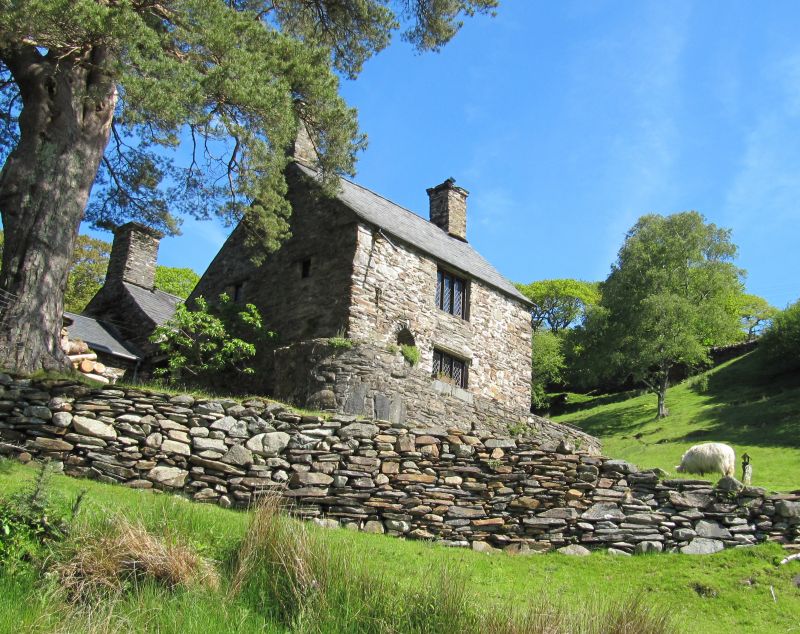
Dduallt is an unusual example of the 'unit-system' of linked dwellings, in which two parallel ranges are linked by a storeyed lobby giving independent access to each. The relationship between the two ranges in uncertain, but the rear range is likely to be the earlier of the two (the small front range has an ancillary character), though both are probably late C16. The front range is thought to have served as a parlour, but the layout suggests that it was originally a small separate dwelling. A barn or byre attched to the rear range is a later addition. The house had been abandoned at the time of the original listing survey in 1951, and was restored by Colonel Campbell in the 1960s. Associated with the house is a walled garden - rare in Merionydd. extensively renovated in the later C20.
Farmhouse, planned according to the 'unit- system' of linked dwellings, the 2 ranges here connected by a small covered court or porch. The rear unit has a barn or byre to rear and a kitchen addition at one gable; at the far end of the barn are a pair of modern single storey additions.
The principal range, to front, is built of rubble masonry; slate roof with tall square stone gable stacks with dripstones and capping. Offset to L of the front lateral wall are ground and first floor windows of 3-lights, the ground floor window in a former doorway accessed by an external flight of stone steps. The present door is to far L of the range and is a narrow door with rounded head. At the R gable return windows flank the chimney at ground, 1st and attic floor level; deeply recess and housing modern timber mullioned and casement windows, attic windows retain earlier diagonally set timber mullions. The L gable return has somewhat scattered fenestration of small windows; 1st floor windows flanking the fireplace and with plain flat labels across the window heads.
The porch has a segmentally headed doorway with a head of radiating stones and
small window above recessed into a rectangular opening between the 2 wings; a lions head above the doorway a later addition.
The rear range is a 2-storey block built of mortared rubble masonry; slate roof with tall gable stacks with dripstones and capping, that to L a massive stack. The front lateral wall (facing the front house or unit) has a single ground and first floor window close to the porch; the ground floor window is a 3-light timber casement and the first floor casement of 2-lights is set in a gabled half dormer that breaks the eaves line. There is a small window at ground floor level in the R gable return and at the L gable projecting dripstones indicate the roof line of the original single storey wing, extensively rebuilt in late C20; with modern lights, a gabled half dormer in the rear roof pitch and a large round-headed window in the end gable.
The agricultural buildings to rear have been extensively modernised and extended, the barn has timber casements and french doors; the addition to rear has a glazed roof and tall round-headed windows along one lateral wall.
The two elements of the house are linked by the central lobby on both floors. Rear range appears to have comprised hall with gable-end fireplace, and small unheated service room. Collared truss with arched doorhead cut into the collar. The smaller front range comprised a single room, serving as the parlour as the houses were integrated, though perhaps originally representing a small independent dwelling unit. It has a mural stair in the rear wall, the only access to the first floor of both units.
Listed as a fine and unusual example of sub-medieval planning, forming linked dwellings. Retains good traditional character.
External links are from the relevant listing authority and, where applicable, Wikidata. Wikidata IDs may be related buildings as well as this specific building. If you want to add or update a link, you will need to do so by editing the Wikidata entry.


Other nearby listed buildings
