History in Structure

Pont Dol-y-Moch (partly in Maentwrog)

A Grade II* Listed Building in Ffestiniog, Gwynedd

More Photos »
Approximate Location Map
Large Map »

Coordinates

Latitude: 52.9561 / 52°57'21"N

Longitude: -3.9591 / 3°57'32"W

OS Eastings: 268492

OS Northings: 341649

OS Grid: SH684416

Mapcode National: GBR 5X.KYJY

Mapcode Global: WH55H.4YZP

Plus Code: 9C4RX24R+C9

Entry Name: Pont Dol-y-Moch (partly in Maentwrog)

Listing Date: 24 April 1951

Last Amended: 6 July 2007

Grade: II*

Source: Cadw

Source ID: 4694

Building Class: Transport

Also known as: Pont Dol-y-Moch

ID on this website: 300004694

Location: Spanning the Afon Dwyryd about 1km SE of Rhyd-y-sarn at the SW boundary of Ffestiniog Community with Maentwrog Community, and carrying the narrow lane that runs along the north side of the Vale of Ff

County: Gwynedd

Community: Ffestiniog

Community: Ffestiniog

Locality: Vale of Ffestiniog

Traditional County: Merionethshire

Tagged with: Bridge Road bridge

Find accommodation in
Ffestiniog

History

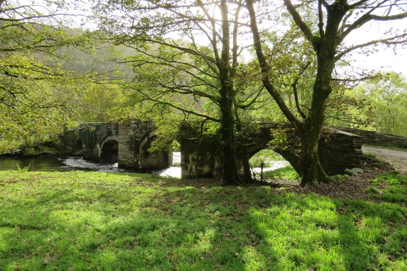
There is no direct dating evidence for the bridge, but it is thought to be C16. Its proximity to the important gentry house of Plas Dol-y-moch may give a context for its construction: the house has late C16 origins, but was extended in 1643.

Exterior

A fine 4-arched bridge. Rubble construction with wide segmental arches with arch rings and rough-dressed voussoirs. Rubble cutwaters to both sides with contemporary stone benches to central refuges, and low rubble parapets with large original coping stones. The parapet walls curve outwardly at both ends. Slightly cambered tarmacked roadway.

Reasons for Listing

Listed grade II* as a fine early bridge, exceptionally well-preserved in its original, un-widened state.

External Links

External links are from the relevant listing authority and, where applicable, Wikidata. Wikidata IDs may be related buildings as well as this specific building. If you want to add or update a link, you will need to do so by editing the Wikidata entry.

Recommended Books

Other nearby listed buildings

  • II* Pont Dol-y-Moch (partly in Ffestiniog)
    Spanning the Afon Dwyryd about 1km SE of Rhyd-y-sarn at the SW boundary of Ffestiniog Community with Maentwrog Community, and carrying the narrow lane that runs along the north side of the Vale of Ff
  • II Pont Dol-Rhiw-Felen
    Spanning a tributary of the Afon Dwyryd about 1km SE of Rhyd-y-sarn at the SW boundary of this community area with that of Maentwrog.
  • II Pont Dol-rhiw-felen
    Spanning a tributary of the Afon Teigl, carrying the narrow country road that runs along the N side of the Vale of Ffestiniog between the A487(T) and the B4391; c.2kms ENE of Maentwrog.
  • II Plas Dol-y-moch
    On the narrow country road that runs along the N side of the Vale of Ffestiniog between the A487(T) and the B4391; ENE of Maentwrog.
  • II Cae'n y Coed Uchaf
    On S side of A487 approximately half-way between Maentwrog and Gellilydan. Left (N) gable end to road, small walled foregarden to front of house.
  • II Dduallt (also known as Plas y Dduallt)
    In an isolated rural location raised high above the N side of the narrow country road that runs along the N side of the Vale of Ffestiniog between the A487(T) and the B4391; ENE of Maentwrog.
  • II Penralltgoch
    Located approximately 0.5km W of Ffestiniog village on a slightly raised terrace on the steep roadside.
  • II Church of St Michael
    On a promontory of high ground at the western end of Llan Ffestiniog, set back slightly from the informal village square.

BritishListedBuildings.co.uk is an independent online resource and is not associated with any government department. All government data published here is used under licence. Please do not contact BritishListedBuildings.co.uk for any queries related to any individual listed building, planning permission related to listed buildings or the listing process itself.

British Listed Buildings is a Good Stuff website.