Approximate Location Map
Large Map »
Latitude: 53.4091 / 53°24'32"N
Longitude: -4.5257 / 4°31'32"W
OS Eastings: 232210
OS Northings: 393224
OS Grid: SH322932
Mapcode National: GBR HM6P.FPG
Mapcode Global: WH41Y.GK3W
Plus Code: 9C5QCF5F+JP
Entry Name: Church of St Rhwydrys
Listing Date: 12 May 1970
Last Amended: 27 November 2000
Grade: II*
Source: Cadw
Source ID: 5382
Building Class: Religious, Ritual and Funerary
Also known as: St Rhwydrys's Church, Llanrhwydrys
St Rhwydrus's Church
ID on this website: 300005382
Location: In an isolated rural location near the coast at Cemlyn. The churchyard is reached via a trackway leading SW from the farmtrack to Tyn Llan farm, and then via a footpath across a field.
County: Isle of Anglesey
Community: Cylch-y-Garn
Community: Cylch-y-Garn
Locality: Cemlyn
Traditional County: Anglesey
Tagged with: Church building Medieval architecture
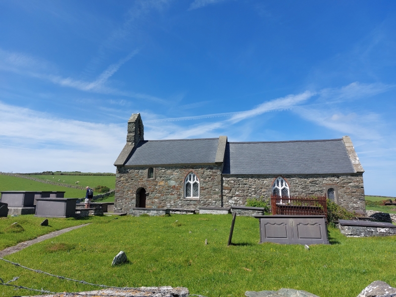
First mentioned in the Norwich Taxation of 1254, the fabric of the church appears to date back to C12, now comprising the nave of the present church and including the C12 round arched S doorway. The long chancel appears to be an addition to this early nave, added in C13; the N chapel is of uncertain date. The E wall and part of the N wall were rebuilt in the C15. There is a gallery at the W end of the church, with the inscription and date: M. I. H. RECDOR T P H S 1776. The Reverend John Hughes was rector of Llanrhuddlad with Llanrhwydrus from 1755-1778; T P and H S were thought to be churchwardens of the time, possibly Thomas Prys and Hugh Shadrach. The church has been renovated in recent years, with money collected by the local farms.
Simple rural church, largely early Medieval but with Perpendicular detail; short nave with W bellcote, and long chancel stepped down, with N chapel. Built of local rubble masonry with freestone dressings; modern slate roof with wide stone coping, W gable bellcote. Nave of 2 bays with entry to the church through narrow round-headed C12 doorway with rough voussoir arch over advanced springing course to SW. There is a small camber-headed leaded light to the gallery set under the eaves and offset to E of doorway; E bay has a pointed-arched window of 2 lights and plain panel tracery. A similarly detailed window is in the SW bay of the chancel, the SE bay with a leaded light as for the gallery window. The E window is also a pointed-arched window of 2 lights, with cusped panel tracery. The N chapel has narrow leaded lights in N and E walls. The bell in the W bellcote is said (by RCAHM) to be inscribed with the initials, names and dates: W L R W 1721 LLANRYDWRYS / R WIGGAN A LUKE FECIT / ASHTON WRXAM.
Entry to the church is via the round-headed SW doorway which leads into vestibule formed by a screen directly below the gallery at the W end of the nave. Directly opposite the entrance is a large plain cylindrical C12 font. This stands on a shallow shelf which runs W along the N wall, and along the W wall; wooden steps lead up the gallery in the SW corner. The W gallery is supported on a wide chamfered beam and exposed joists. Entry to the church is through a doorway to the N end of a beaded, boarded partition; the door itself has 2 pointed-arched panels.
Nave of 2 roof bays, the chancel 3 roof bays; divided by C13 pointed-arch with square responds and plain imposts. The roof timbers are exposed, the nave and chancel have braced and collared C13 crucks, that to the E end with N blade exposed when the N chapel was constructed. The easternmost bay over the chancel has a panelled roof with diagonally set tongue and groove panelling between chamfered dividers; intersections with Tudor flower bosses. Above the E cruck collar there is splayed panelling above a Tudor flower, this encloses the chancel roof at its W end. The N chapel is of a single roof bay, with C19 collared truss and purlins with beaded angles.
The fittings are of pitch pine, the lower parts of the nave and N chapel walls are panelled, and the rear pew of the chapel is formed by simple bench; other pews have shaped ends and slatted, angled backs with hymn book rests along the backs. At the W end of the nave the gallery front has a moulded rail on shaped balusters, below which is a shaped frieze and an inscription and date which reads: M. I. H. RECDOR T P H S 1776.
The sanctuary rail is moulded on plain balusters; trefoil headed pierced panels with circles within the angles between form an open 'arcade'. The reading desk is similarly detailed. Set in the base of the S wall of the sanctuary is a gravestone to cousins Richard (son of Thomas of Orsedd) and Owen (son of Rice at Plas Cemlyn) Price; both died in 1783. There is also a single slate memorial slab along the S wall of the nave, to Shadrach Williams of Fronddu, Cemlyn d. 1808, and his wife Catherine d. 1819.
Listed as an early Medieval church in characteristically isolated location. The building is unusual for its cruck construction, and retains simple fittings including a rare C18 west gallery.
External links are from the relevant listing authority and, where applicable, Wikidata. Wikidata IDs may be related buildings as well as this specific building. If you want to add or update a link, you will need to do so by editing the Wikidata entry.


Other nearby listed buildings
