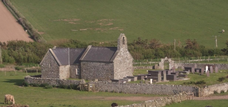
Lychgate at Church of St Rhwydrys
A Grade II Listed Building in Cylch-y-Garn, Isle of Anglesey
Coordinates
Latitude: 53.4089 / 53°24'32"N
Longitude: -4.5257 / 4°31'32"W
OS Eastings: 232213
OS Northings: 393203
OS Grid: SH322932
Mapcode National: GBR HM6P.FPK
Mapcode Global: WH41Y.GL41
Plus Code: 9C5QCF5F+HP
Entry Name: Lychgate at Church of St Rhwydrys
Listing Date: 27 November 2000
Grade: II
Source: Cadw
Source ID: 24411
Building Class: Religious, Ritual and Funerary
ID on this website: 300024411
Location: Located at the entrance to the churchyard for the Church of St Rhwydrys; reached via a trackway leading SW from the farmtrack to Tyn Llan farm, and then via a footpath across a field.
County: Isle of Anglesey
Community: Cylch-y-Garn
Community: Cylch-y-Garn
Locality: Cemlyn
Traditional County: Anglesey
Tagged with:
Lychgate
History
The lychgate is similar in style and construction to many on the island, a characteristic local type presumed to be C18 or C19.
Exterior
Simple lychgate built of local rubble masonry, stepped up at the sides; top with stone coping and pyramidal stone centrally placed over round-headed arch of rough stone voussoirs. The tall wrought iron gate has alternate tall and short vertical rails with arrowhead finials; side vertical rails are scrolled.
Reasons for Listing
Included as a good rural lychgate of characteristic local type which forms a group with the adjacent Church of St. Rhwydrys.
External Links
External links are from the relevant listing authority and, where applicable, Wikidata.
Wikidata IDs may be related buildings as well as this specific building. If you want to add or update a link, you
will need to do so by editing the Wikidata entry.
Recommended Books
Other nearby listed buildings
-
II*
Church of St Rhwydrys
In an isolated rural location near the coast at Cemlyn. The churchyard is reached via a trackway leading SW from the farmtrack to Tyn Llan farm, and then via a footpath across a field.
-
II
Hammels at Plas Cemlyn
Set back from the S side of the country road running along the N coast of the island at Cemlyn Bay. The farmstead at Plas Cemlyn is located c1km SE of the Church of St Rhywydrys. The hammels lie c50
-
II
Old farmhouse at Plas Cemlyn
Set back from the N side of the country road running along the N coast of the island at Cemlyn Bay. The farmstead at Plas Cemlyn is located c1km SE of the Church of St Rhywydrys, the old farmhouse is
-
II
Agricultural range at Plas Cemlyn
Set back from the S side of the country road running along the N coast of the island at Cemlyn Bay. The farmstead at Plas Cemlyn is located c1km SE of the Church of St Rhywydrys, the range lies acros
-
II
Farmhouse at Plas Cemlyn with curved walling to north and wall incorporating goose pens to south
Set back from the S side of the country road running along the N coast of the island at Cemlyn Bay. The farmstead at Plas Cemlyn is located c1km SE of the Church of St Rhywydrys.
-
II
Stable with servants quarters at Caerau
Located at the N side of the trackway leading to Caerau. The house is set back from the W side of a country road c750m NW of the Church of St Mary at Llanfairynghornwy; the stables are located c80m N
-
II*
Caerau
In an isolated rural location set back from the W side of the country road between Llanfairynghornwy and Cemlyn; c750m NW of the Church of St Mary at Llanfairynghornwy.
-
II
Gatepiers to south courtyard at Caerau
Located along the SW wall of the S courtyard of the house at Caerau. The house is set back from the W side of a country road c750m NW of the Church of St Mary at Llanfairynghornwy.