Approximate Location Map
Large Map »
Latitude: 53.2359 / 53°14'9"N
Longitude: -4.2807 / 4°16'50"W
OS Eastings: 247879
OS Northings: 373416
OS Grid: SH478734
Mapcode National: GBR 5H.04MF
Mapcode Global: WH42V.6XTN
Plus Code: 9C5Q6PP9+9P
Entry Name: Church of St Michael (old church)
Listing Date: 30 January 1968
Last Amended: 20 October 1998
Grade: II
Source: Cadw
Source ID: 5499
Building Class: Religious, Ritual and Funerary
ID on this website: 300005499
Location: In an isolated location, set back from the NW side of a country road and reached only by footpath. The church remains lie within an enclosed churchyard, c1.4km N of the new Church of St. Michael, Gae
County: Isle of Anglesey
Community: Llanfihangel Ysgeifiog
Community: Llanfihangel Ysgeifiog
Locality: Gaerwen
Tagged with: Church building
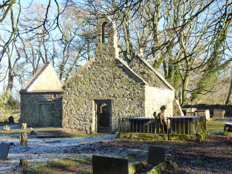
The roofless remains of the church represent the eastern part of a C15 nave and chancel, with a N chapel added in 1638 by the Holland family of Plas Berw. The parish of Llanfihangel Esgeifiog underwent a number of changes in the early C19. There was a growth in population around the Pentre Berw area, brought about by the influx of workers to the nearby coalmines, and the building of Telford's new road across the island also led to an increase in population along its route. In the 1840's it was decided to build a new church and National School at the present, more central, location in Gaerwen, the new church of St Michael erected in 1847. The old church was then made smaller, the western part of the nave removed and the W wall erected, a chapel to the S removed and the opening blocked up c1874.
The eastern part of the original church remains, consisting mainly of the chancel and N chapel. Walls of rubble masonry with sandstone dressings; walls are full height but the church is now roofless. Entrance is through a doorway in the W wall of the chancel; a reset mid C15 pointed-arched opening in a square frame with moulded and shafted jambs and a moulded label and quatrefoils in the spandrels. The W wall also carries the original reset gabletted bellcote. The S wall has been rebuilt, the W respond of the opening to the chapel is still visible; the N wall has a mid C15 rectangular window with moulded jambs and head and the opening to the N chapel has been narrowed. The E chancel wall has a late C16 window of 3 round-headed lights in a square frame with cavetto mullions and moulded hoodmould. Similarly detailed windows are in the N and E walls of the N chapel; the W wall has a blocked round-headed window to the S with chamfered jambs and straight hoodmould, to the N is a blocked doorway with depressed pointed-arched head and similar hoodmould. Above the E chancel window is a datestone with shield, initials, date I E S 1598, and the letters T R and R W inscribed in the angles of the return of the label; a stone near the jamb has an inscription (partly illegible) PWYBYNAC / A WNEL TAVA / RN O EGLWYS / DUW ...... TO / ...... A contemporary inscription runs around the outer fillet of the frame in the W doorway: OETTA [Y] ADRODD [YN Y] DRWS / PADER A GWEDDI DROS ENAID [W] AP [HOLL] AP DD AC ENEIDIEU ME[I] / RW [A C]HRISTNOGION Y BYD; and on a panel above the N window of the chapel T H MILES POSSIDET HA / NC CAPELLAM / LAVS DEO / V[L]T FEBR / 163(8). The roughly circular churchyard is enclosed by a low rubble wall with roughly embattled parapet, and the churchyard contains a number of C18 and C19 slate chest tombs.
Listed as the substantial remains of a C15 church with C17 additions. During the mid C19 many of the old churches on the island were extensively renovated or rebuilt, but a new church was built to replace this one on a new site, and as a result these remains constitute an important survival, retaining unrestored original late medieval features.
External links are from the relevant listing authority and, where applicable, Wikidata. Wikidata IDs may be related buildings as well as this specific building. If you want to add or update a link, you will need to do so by editing the Wikidata entry.


Other nearby listed buildings
