Approximate Location Map
Large Map »
Latitude: 53.1911 / 53°11'27"N
Longitude: -4.3271 / 4°19'37"W
OS Eastings: 244621
OS Northings: 368526
OS Grid: SH446685
Mapcode National: GBR 5F.2Z7K
Mapcode Global: WH436.H1PZ
Plus Code: 9C5Q5MRF+C5
Entry Name: Church of St Caffo
Listing Date: 30 January 1968
Last Amended: 19 October 1998
Grade: II
Source: Cadw
Source ID: 5508
Building Class: Religious, Ritual and Funerary
Also known as: St Caffo's Church, Llangaffo
ID on this website: 300005508
Location: Located within an enclosed churchyard, set back from the SE side of the B4419 at the NE end of Llangaffo.
County: Isle of Anglesey
Community: Rhosyr
Community: Rhosyr
Locality: Llangaffo
Tagged with: Church building Gothic Revival
Built in 1846 by Weightman and Hadfield, architects of Sheffield, near the site of the old church which it replaced.
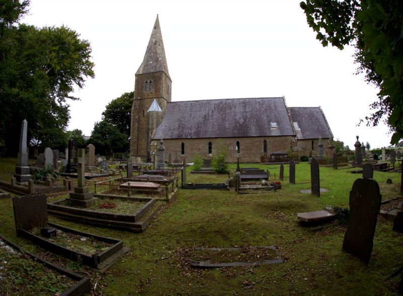
Early English style church with nave of 4 bays; shorter, narrower chancel at E end with N transept, and W tower with spire; lean-to additions on E wall of N transept and S wall of chancel. Built of rubble masonry (S facing walls, and E wall of tower rendered) with limestone dressings. Slate roof with stone copings. Lancet windows to nave, angles with offset buttresses. Chancel has single lancet window in S wall and a pointed-arched E window of 3-lights. N transept has paired round-headed lights in N gable and depressed pointed-arched doorway in W wall; E wall has lean-to extension with tall ashlar stack at junction. W tower of 3 stages incorporating entrance in lower stage with pointed arched doorway in N face; stage above with narrow lancet windows; belfry above a moulded string, with paired trefoil-headed louvred lights. Tower has tall buttresses at angles and stair tower at SE corner lit by single lancet window; broach spire. The churchyard contains the remains of a weathered C9 or C10 cross shaft and six C9-C11 gravestones and one which is C12 or C13.
Entry to church through pointed-arched doorway at W end of the nave. Nave of 6 roof bays; chancel of 4 bays, with exposed collared trusses. Sanctuary is raised by one step, with encaustic tiles and moulded sanctuary rail on fretwork stanchions. Reredos formed by recessed panels of encaustic tiles. Pulpit with facing panels with floriate carving under a moulded cornice. C12 font is a circular bowl tapering to the base where it is cut to fit a modern octagonal plinth; redressed surface decorated with panels containing chevrons. N wall of the N transept has C17 memorials; central memorial formed by the fragments of an alabaster mural monument, consisting of a portion of the broken pediment, the top part of a panel with a winged cherub's head and a broken scrolled pediment with a small plate on which is a M'iae SACRUM and an achievement, c1660. Flanking this are slate memorial plaques; left hand to Edward Wynne, D.D., d.1669, and his wife Sydney, d.1670; right hand to Elizabeth White, wife of Hugh Hughes, d. 1630. Below the right hand plaque is an early C7 inscription stone set into the wall, formerly from Fron-Deg, Newborough, a rough schist stone with the inscription: ..VI / RNIN / FILIUS / CUURIS / CINI / ERE / XIT / HUNC / LAPI / DEM. Within the porch is a fragment of a pierced wheel C9-10 cross head, with interlaced work of 3 strands on each side.
Listed as a mid C19 rural church, consistently articulated and detailed in an Early English style.
External links are from the relevant listing authority and, where applicable, Wikidata. Wikidata IDs may be related buildings as well as this specific building. If you want to add or update a link, you will need to do so by editing the Wikidata entry.


Other nearby listed buildings
