Approximate Location Map
Large Map »
Latitude: 53.4153 / 53°24'55"N
Longitude: -4.3329 / 4°19'58"W
OS Eastings: 245048
OS Northings: 393482
OS Grid: SH450934
Mapcode National: GBR HMNN.ZZW
Mapcode Global: WH421.DFY2
Plus Code: 9C5QCM88+4R
Entry Name: Lighthouse and watchtower, with attached building at the entrance of the old harbour
Listing Date: 7 August 1974
Last Amended: 12 December 2000
Grade: II
Source: Cadw
Source ID: 5718
Building Class: Recreational
Also known as: Lighthouse and watchtower, with attached building at the entrance of the old harbour
ID on this website: 300005718
Location: Located at the W end of the pier at the N end of the Lower Basin or outer part of the old harbour.
County: Isle of Anglesey
Town: Amlwch
Community: Amlwch
Community: Amlwch
Locality: Porth Amlwch
Built-Up Area: Amlwch
Traditional County: Anglesey
Tagged with: Lighthouse
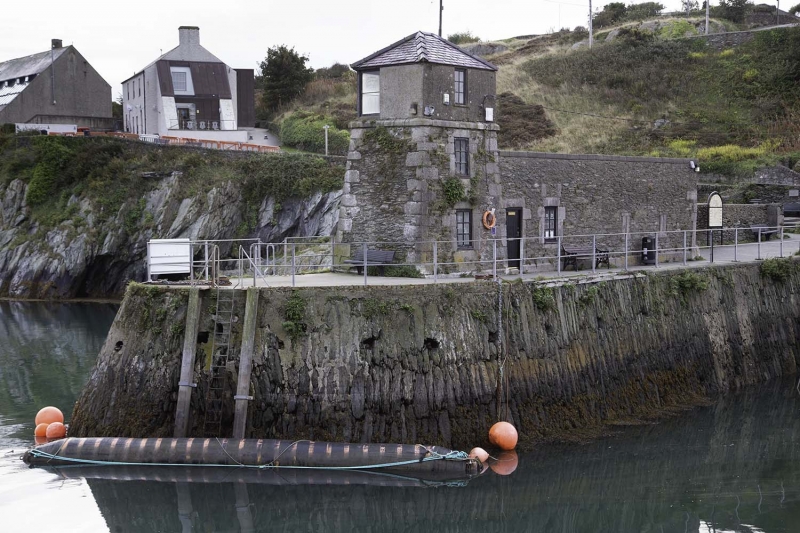
Lighthouse and watchtower built in 1853, with attached building, now in use as an exhibition centre. In 1768 a rich deposit of copper ore was discovered on Parys Mountain, to the south of Amlwch, and for a generation the two opencast mines of Parys and Mona became the largest producers of copper in the world, with over 3000 tons(3048 tonnes) of copper produced annually between 1773 and 1785. The exported ores, copper and sulphur, and imported coal, was carried by ship, and the existing harbour at Amlwch was deemed inadequate for the vastly increased volume of traffic. In 1793 an Act of Parliament was passed which permitted the "...enlargement, deepening, cleansing, improvement and regulation of the harbour". Among the reasons given were the benefits of the additional safety to shipping as well as providing a retreat for ships in storms.
The harbour was further improved in 1816 by the building of a pier at its N end; the lighthouse and watchtower were erected in 1853. The harbour was also the scene of a busy ship building industry in C19.
Mid C19 3-storey lighthouse and watchtower with long single storey range to E. Built of rubble masonry with limestone dressings and plinth; slate roofs. The lighthouse and watchtower has battered walls and a hipped roof. The lower 2 storeys have exposed stonework including large limestone quoins at angles; above the 2nd storey is a slightly advanced string course above which the elevations are rendered. Windows are 6-pane casements, one to each storey of the S elevation, a single upper storey window at the W end of the N elevation (facing out to sea).
The long range built against the E wall of the tower was probably built with a gable roof, now raised along the S wall and with a single pitched roof sloping down to the N. The S elevation has a doorway at the far L (W) end with a 6-pane casement window to its R; offset to the R end of the range are 2 narrow slots. At the far R (E) end there is a wide doorway with shallow cambered head inscribed with the date 1853.
Interior not inspected at the time of the survey.
Listed as good, well-preserved, mid C19 lighthouse and watchtower which retains original character. The harbour was built originally to cater for the increased passage of shipping created by the industrial developments at Parys Mountain; the lighthouse and watchtower erected on the N pier was an important component part of the later C19 harbour development, based around the ship-building industry.
External links are from the relevant listing authority and, where applicable, Wikidata. Wikidata IDs may be related buildings as well as this specific building. If you want to add or update a link, you will need to do so by editing the Wikidata entry.


Other nearby listed buildings
