Approximate Location Map
Large Map »
Latitude: 53.2226 / 53°13'21"N
Longitude: -4.4741 / 4°28'26"W
OS Eastings: 234923
OS Northings: 372364
OS Grid: SH349723
Mapcode National: GBR 57.0ZKY
Mapcode Global: WH42Y.78Q9
Plus Code: 9C5Q6GFG+29
Entry Name: Ty Croes signal-box and attached station range
Listing Date: 24 June 1986
Last Amended: 25 November 1998
Grade: II
Source: Cadw
Source ID: 5733
Building Class: Transport
ID on this website: 300005733
Location: Located on the SE side of the T-junction; directly on the N side of the level crossing at Ty Croes.
County: Isle of Anglesey
Community: Aberffraw
Community: Aberffraw
Locality: Ty Croes
Traditional County: Anglesey
Tagged with: Signal box
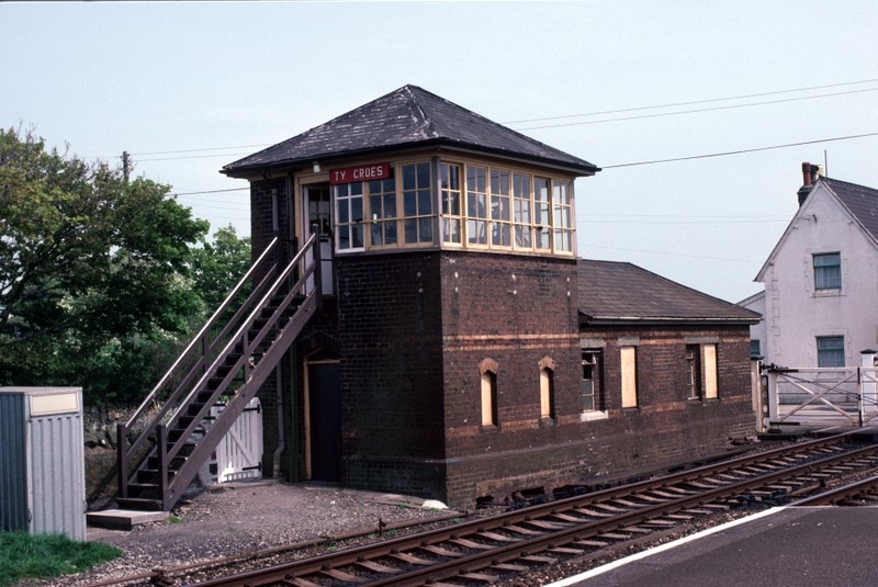
Built in 1872 to accommodate Saxby-Farmer signalling equipment and following the Saxby-Farmer designs, though probably built by the Chester and Holyhead railway works. In 1989 the signal-box was downgraded and all the signalling equipment removed; used now only for the purpose of operating the adjacent level crossing.
Two-storey signal-box with integral single storey range of booking office and waiting room at E end. Built of dark red brick with yellow brick dressings (including sill boards and string courses). Pyramidal slate roof to signal-box, hipped slate roof to E range; both with projecting eaves and brick stacks to rear (N). Wrap-round small-pane glazing with horizontal sliding sashes to signal-box; doorway with openwork timber stair to right gable-end. Triangular-headed ground floor openings (windows now boarded). Blocked openings towards railway lines. Original name plates.
Listed as a well-preserved example of one of the signal-box and station ranges built to serve the Anglesey section of the Chester to Holyhead railway; a well-composed design enhanced by decorative brickwork detailing. The range at Ty Croes is of particular interest as it includes one of the oldest signal-boxes in use in Britain, albeit on a reduced level.
External links are from the relevant listing authority and, where applicable, Wikidata. Wikidata IDs may be related buildings as well as this specific building. If you want to add or update a link, you will need to do so by editing the Wikidata entry.


Other nearby listed buildings
