Approximate Location Map
Large Map »
Latitude: 51.7999 / 51°47'59"N
Longitude: -4.744 / 4°44'38"W
OS Eastings: 210894
OS Northings: 214813
OS Grid: SN108148
Mapcode National: GBR CW.XV7V
Mapcode Global: VH2P5.Q1F0
Plus Code: 9C3QQ7X4+XC
Entry Name: The Emporium
Listing Date: 17 May 1988
Last Amended: 17 May 1988
Grade: II
Source: Cadw
Source ID: 6501
Building Class: Commercial
ID on this website: 300006501
Location: Adjoining Hill House and stepped down to the right at the junction with Northfield Road.
County: Pembrokeshire
Community: Narberth (Arberth)
Community: Narberth
Built-Up Area: Narberth
Traditional County: Pembrokeshire
Tagged with: Architectural structure
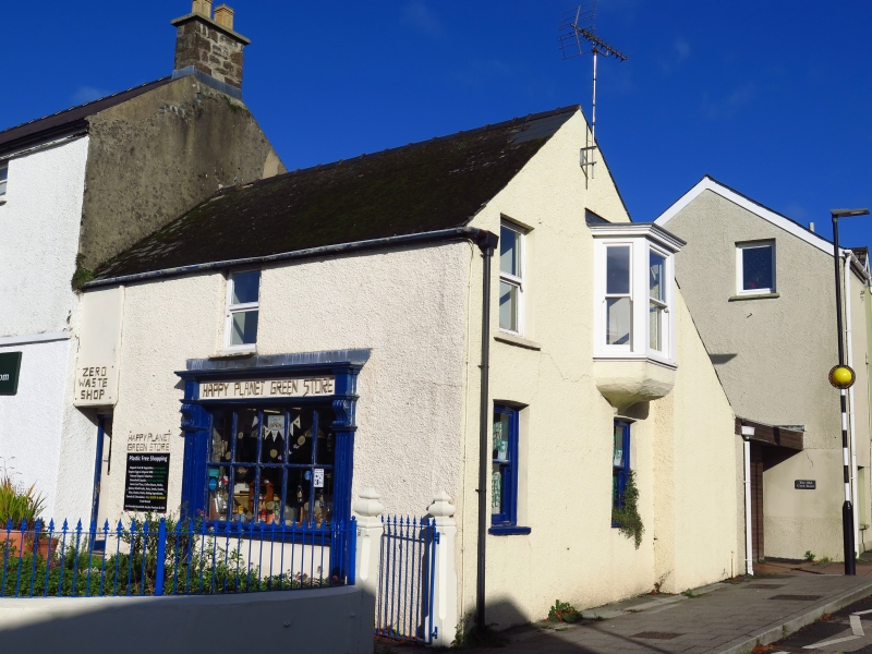
C19, 2 storey shop, colourwashed roughcast on rubble. Steeply pitched slate roof, continuous outshot to rear. Plain eaves. Truncated brick stack to right, tall brick stack to outshot..
Victorian sash window to 1st floor. C10 shop window to ground floor, 10 pane transomed window. Reeded pilasters, rectangular fascia ends on consoles.
Modern doorway to left below large rectangular nameboard (gives access also to adjoining Hill House).
Good C19 iron railings to forecourt, contemporary gateway to right.
2 window elevation to Northfield road. Victorian oriel window to 1st floor right.
Tripartite on moulded bracket with dentil cornice. Sash window to left. Similar to ground floor. Plain reveals, slate sills.
Group value with Hill House and Coach Horses Inn on opposite corner.
External links are from the relevant listing authority and, where applicable, Wikidata. Wikidata IDs may be related buildings as well as this specific building. If you want to add or update a link, you will need to do so by editing the Wikidata entry.


Other nearby listed buildings
