Approximate Location Map
Large Map »
Latitude: 51.7978 / 51°47'52"N
Longitude: -3.7293 / 3°43'45"W
OS Eastings: 280846
OS Northings: 212433
OS Grid: SN808124
Mapcode National: GBR Y7.XTWZ
Mapcode Global: VH5G3.92TM
Plus Code: 9C3RQ7XC+47
Entry Name: 12 Lamb & Flag Cottages
Listing Date: 17 January 1963
Last Amended: 4 December 2001
Grade: II
Source: Cadw
Source ID: 6607
Building Class: Domestic
ID on this website: 300006607
Location: Situated at S end of terraced row on S bank of Tawe, reached by temporary bridge from Rheolau Arms Inn.
County: Powys
Town: Swansea
Community: Ystradgynlais
Community: Ystradgynlais
Locality: Gwaunclawdd
Traditional County: Brecknockshire
Tagged with: Cottage
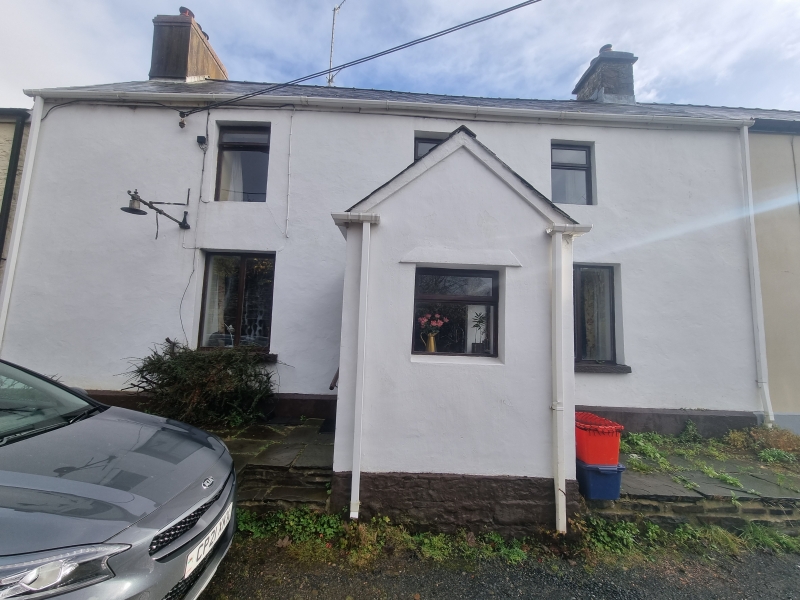
In 1801, when Thomas Malkin passed, Pentre'r Lamb was a settlement of two inns and a few houses with a small mine by the river, near the canal-head of the Swansea Canal. No 12, the former Lamb and Flag Inn, and No 14 may have been originally part of one large house or inn. Restored and extended in matching style c2000.
Terraced house, painted render with slate close eaved roofs and square rendered end stack to original range. Two-storey, two-window original part with two 12-pane hornless sashes above, centre 16-pane cambered-headed sash below and 6-panel door with overlight to left. All windows and door restored c2000 when matching one-window range was added to right, slightly lower roof and slightly set back. Rendered end stack. 12-pane sash over 16-pane sash, matching those on original range. Twelve-pane sash on each floor on end wall. Tooled stone sills throughout.
Parallel rear range continued along behind No 12, thin coursed rubble stone with slate roof. Two 12-pane sashes above, one centre 16-pane sash below, with cambered heads and stone voussoirs. Gabled single storey outbuilding to right, at right angles, shared with No 12.
Not inspected.
Included with No 12 as remnant of a small rural industrial/agricultural settlement illustrative of the early industrial history of the region.
External links are from the relevant listing authority and, where applicable, Wikidata. Wikidata IDs may be related buildings as well as this specific building. If you want to add or update a link, you will need to do so by editing the Wikidata entry.


Other nearby listed buildings
