Approximate Location Map
Large Map »
Latitude: 52.1496 / 52°8'58"N
Longitude: -3.4091 / 3°24'32"W
OS Eastings: 303681
OS Northings: 251084
OS Grid: SO036510
Mapcode National: GBR YN.6P0S
Mapcode Global: VH69Z.V7LF
Plus Code: 9C4R4HXR+R8
Entry Name: Old Pendre
Listing Date: 16 September 1991
Last Amended: 5 March 1992
Grade: II
Source: Cadw
Source ID: 7522
Building Class: Domestic
ID on this website: 300007522
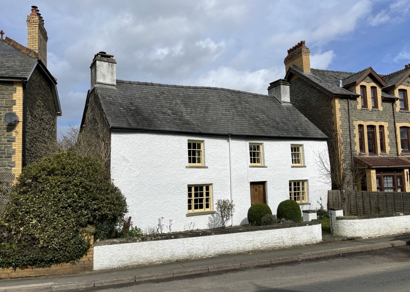
Location: Late eighteenth century farmhouse with earlier eighteenth century origins. Formerly known as 'Ystrad' as recorded on 1842 Tithe Map. Operated as farm until 1880's.
County: Powys
Community: Builth (Llanfair-ym-Muallt)
Community: Builth
Built-Up Area: Builth Wells
Traditional County: Brecknockshire
Tagged with: Building
Slate roofs, rubble masonry, painted and part rendered. Some weatherboarding to rear.
Central entry house with end chimneys. Later block faces Garth Road. Earlier connected wing at right angles and to rear.
Garth Road elevation has two storeys below undulating roof and rendered end chimneys. Three first floor windows (nine small panes in horned sashes with narrow glazing bars). On ground floor, flanking central doorway, larger three part sash windows divided by wood mullions . Doors and windows offset to right of front to accommodate large living room fireplace at left end of building. Small square window in E gable.
At rear, windows somewhat altered. Dormer in roof with window lighting stairs. Rear 2-storey wing at right angles with some very small rubble masonry still visible. Gable facing N weatherboarded as is upper part of E wall.
Boarded front door gives onto small hall with dogleg stair. To right, small parlour behind which is former dairy, which retains oak shutters and iron bars to N facing window. To left, living room, behind which is kitchen in earlier wing. Details of worked timber suggest later 18th century date with plain beams and joists, boarded doors and partitions. Roof over Garth Road block has standard late king post truss, and plastered rafters suggest that part of roof space was once used as living accommodation.
External links are from the relevant listing authority and, where applicable, Wikidata. Wikidata IDs may be related buildings as well as this specific building. If you want to add or update a link, you will need to do so by editing the Wikidata entry.


Other nearby listed buildings
