Approximate Location Map
Large Map »
Latitude: 52.7788 / 52°46'43"N
Longitude: -3.1556 / 3°9'20"W
OS Eastings: 322149
OS Northings: 320758
OS Grid: SJ221207
Mapcode National: GBR 6Z.XVB9
Mapcode Global: WH793.HFK2
Plus Code: 9C4RQRHV+GQ
Entry Name: Bronhyddon
Listing Date: 31 January 1953
Last Amended: 2 March 2004
Grade: II
Source: Cadw
Source ID: 7639
Building Class: Agriculture and Subsistence
ID on this website: 300007639
Location: Reached by a farm track commencing near the school in Llansantffraid village. House facing south at west side of its farm group.
County: Powys
Community: Llansantffraid (Llansanffraid)
Community: Llansantffraid
Locality: Bronhyddon
Traditional County: Montgomeryshire
Tagged with: Architectural structure
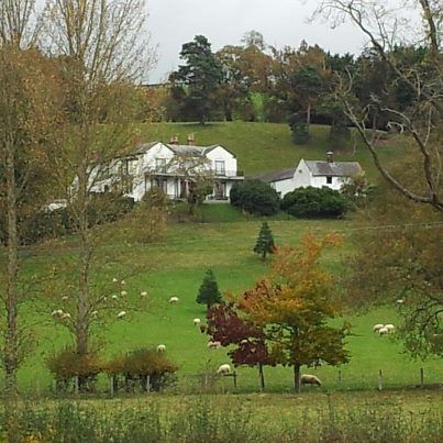
A large farmhouse of the late C18, for which a Royal Exchange insurance policy of c.1790 has been found; the house later embellished at front to accord with Regency fashion. The rear wing said to be indicated on a map dated 1813. The family home of the Simcock/Perrott family, established in Llansantffraid for many generations.
A two-storey, three-window house rendered and painted white; slate roof with red brick chimneys. The roof of the rear wing is slightly stepped down.
The special feature of Bronhyddon is the symmetrical Regency south front, much restored by the present owner, with its central Doric porch flanked by three-light windows under shell tympanum arches. Verandah consisting of a timber lower stage (resembling wrought ironwork) and an iron upper stage. Decorative pebble paving beneath the verandah, recently cleared and restored.
Interior not seen but said to retain contemporary plasterwork in the hall and dining room; simple staircase with scroll newel at foot.
Listed as a fine well-proportioned late Georgian and Regency farmhouse with the additional interest of the attempt of a rural builder to use skillful carpentry to conform to the fashion for decorative ironwork.
External links are from the relevant listing authority and, where applicable, Wikidata. Wikidata IDs may be related buildings as well as this specific building. If you want to add or update a link, you will need to do so by editing the Wikidata entry.


Other nearby listed buildings
