Approximate Location Map
Large Map »
Latitude: 51.8151 / 51°48'54"N
Longitude: -4.6122 / 4°36'43"W
OS Eastings: 220040
OS Northings: 216170
OS Grid: SN200161
Mapcode National: GBR D1.WYF7
Mapcode Global: VH2P2.0MLW
Plus Code: 9C3QR98Q+24
Entry Name: Trevaughan Bridge.
Listing Date: 30 November 1966
Last Amended: 8 March 2001
Grade: II
Source: Cadw
Source ID: 9416
Building Class: Transport
ID on this website: 300009416
Location: Situated at end of no-through road, immediately SW of St. Mary's Church.
County: Carmarthenshire
Town: Whitland
Community: Whitland (Hendy-gwyn)
Community: Whitland
Traditional County: Carmarthenshire
Tagged with: Bridge Road bridge
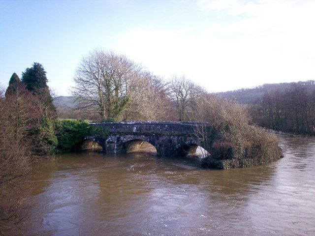
The plaque on the bridge is said to have been dated "1767". N side widened in 1856, to plans by Joseph Jenkins. S side widened by 3 feet (0.914m) in 1878, to designs by Thomas George, and the bridge reinforced at about the same time. In recent years, the road has been diverted, with new bridge, and the embankment to the west removed to prevent flooding.
C18 bridge of three segmental-pointed arches, separated by cutwaters on each side, in rubble stone, with cut stone voussoirs.
Arches separated by cutwaters with concrete plinths and cement capped heads, higher to N side. N side has projecting band below stone parapet, with stone plaque set into walling above. Plaque unreadable, but said to have been dated "1767", and re-set following widening in 1856. S side widened in 1878, with iron rods and ties inserted, having plain disks visible above arches to both sides. Original bridge arches with similar cut stone voussoirs, visible beneath later arches to both sides.
Listed as a good substantial C18 road bridge.
External links are from the relevant listing authority and, where applicable, Wikidata. Wikidata IDs may be related buildings as well as this specific building. If you want to add or update a link, you will need to do so by editing the Wikidata entry.


Other nearby listed buildings
