Latitude: 51.7706 / 51°46'14"N
Longitude: -4.4639 / 4°27'49"W
OS Eastings: 230094
OS Northings: 210869
OS Grid: SN300108
Mapcode National: GBR D7.ZRDF
Mapcode Global: VH3LS.KRZH
Plus Code: 9C3QQGCP+7F
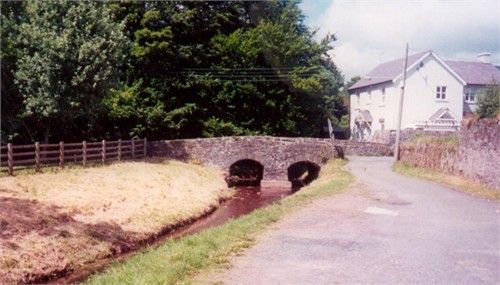
Entry Name: Coran Bridge
Listing Date: 25 September 1986
Last Amended: 25 September 1986
Grade: II
Source: Cadw
Source ID: 9665
Building Class: Transport
ID on this website: 300009665
Location: At the south end of the Cors
County: Carmarthenshire
Community: Laugharne Township (Treflan Lacharn)
Community: Laugharne Township
Built-Up Area: Laugharne
Traditional County: Carmarthenshire
Tagged with: Bridge
Small early C19 (shown on 1834 survey map) rubble single track bridge over the River Coran. Lightly cambered; paired segmental arches with voussoirs and modern base to centre pier. Parapets flanking the roadway and terminating at the end of the abutment.
External links are from the relevant listing authority and, where applicable, Wikidata. Wikidata IDs may be related buildings as well as this specific building. If you want to add or update a link, you will need to do so by editing the Wikidata entry.


Other nearby listed buildings