Approximate Location Map
Large Map »
Latitude: 51.504 / 51°30'14"N
Longitude: -3.5764 / 3°34'35"W
OS Eastings: 290683
OS Northings: 179513
OS Grid: SS906795
Mapcode National: GBR HD.JH3T
Mapcode Global: VH5HJ.YGNF
Plus Code: 9C3RGC3F+HC
Entry Name: Hermon Chapel
Listing Date: 29 September 1986
Last Amended: 29 September 1986
Grade: II
Source: Cadw
Source ID: 11302
Building Class: Religious, Ritual and Funerary
Also known as: Hermon Chapel
ID on this website: 300011302
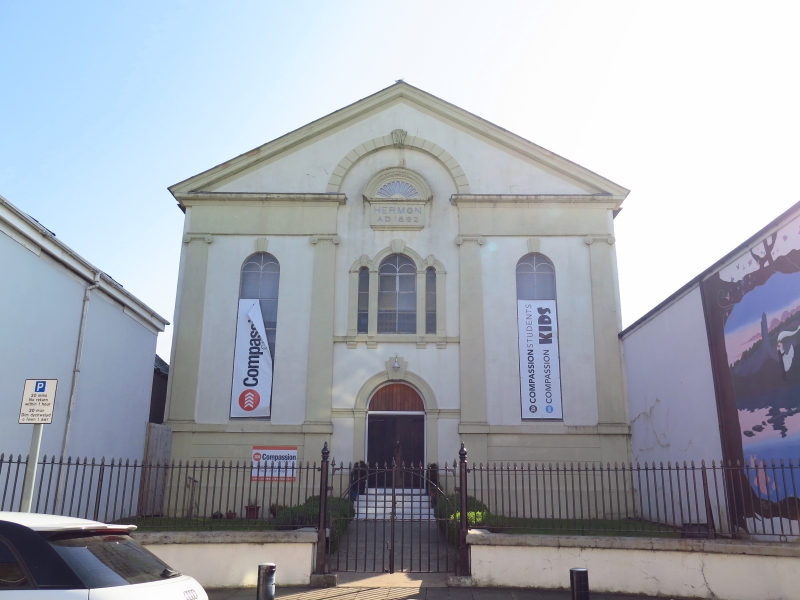
Location: Set back from the road near the junction with Merthyr Mawr Road; former chapel houses forward to the street to left and right.
County: Bridgend
Town: Bridgend
Community: Bridgend (Pen-y-bont ar Ogwr)
Community: Bridgend
Built-Up Area: Bridgend
Traditional County: Glamorgan
Tagged with: Chapel
Dated 1862 (permission granted in June to build a new chapel, vestry and 2 houses) by Robert Roberts at a cost of £2,245.
Italian Renaissance open-pedimented stucco 3-bay front with channelled base and plinth voussoired ‘glorification arch’ to recessed centre. Wide cornice, plain entablature, ionic pilasters on cill band flanking side bays with tall round headed lights; tripartite window to centre with bracketed cill below date plaque (reading Hermon AD 1862) with classical canopy and over raised moulded arched entrance with impost bands; boarded doors. Keystones to all arches.
Broad architraves to tall arched windows on cement render left side, vestry adjoins at rear and reached by side lane.
Contemporary interior with panel-fronted gallery supported on cast-iron columns with foliage capitals. Painted wooden ceiling, trefoil decoration to organ case behind big seat; slightly ramped pews.
Former lower Chapel houses forward to left and right are not of special interest.
External links are from the relevant listing authority and, where applicable, Wikidata. Wikidata IDs may be related buildings as well as this specific building. If you want to add or update a link, you will need to do so by editing the Wikidata entry.


Other nearby listed buildings
