Approximate Location Map
Large Map »
Latitude: 51.5034 / 51°30'12"N
Longitude: -3.5795 / 3°34'46"W
OS Eastings: 290465
OS Northings: 179457
OS Grid: SS904794
Mapcode National: GBR HD.JGBL
Mapcode Global: VH5HJ.XG0V
Plus Code: 9C3RGC3C+95
Entry Name: Cae Court
Listing Date: 29 September 1986
Last Amended: 29 September 1986
Grade: II
Source: Cadw
Source ID: 11299
Building Class: Commercial
ID on this website: 300011299
Location: To NW of St Mary Nolton Church and beside the dual carriageway. Set back behind rubble wall; land drops away steeply to rear.
County: Bridgend
Town: Bridgend
Community: Bridgend (Pen-y-bont ar Ogwr)
Community: Bridgend
Built-Up Area: Bridgend
Traditional County: Glamorgan
Tagged with: Architectural structure
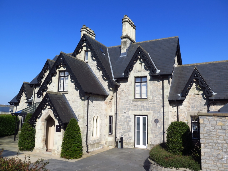
Victorian Gothic heavily gabled 2-storey and attic 3-bay front with 1-storey and attic single bay ranges stepped down to either side. Rubble with freestone dressings; steep pitch slate roof with stone ridge, overhanging eaves and ornamental bargeboards to steep pitch cross gables. Advanced and taller central gable rising to main ridge flanked by stone chimney stacks, with chamfered edges to the grouped flues. Lower and narrower 1 storey and attic gable projects to the front with original porch. Large conservatory by Messenger and Co Ltd, Horticultural Builders of Loughborough. Later small porch extension forward to the street with plain gate piers and boarded door. Cross-frame windows, blocked to side bays, paired cusped lancets to sides of entrance hall.
Central bay to rear advanced with 1st floor timber gabled oriel on metal supports; some blocked windows to rear.
Pointed arch inner door; conversion to offices has altered interior.
Group value.
External links are from the relevant listing authority and, where applicable, Wikidata. Wikidata IDs may be related buildings as well as this specific building. If you want to add or update a link, you will need to do so by editing the Wikidata entry.


Other nearby listed buildings
