Latitude: 51.5106 / 51°30'38"N
Longitude: -3.5797 / 3°34'46"W
OS Eastings: 290470
OS Northings: 180259
OS Grid: SS904802
Mapcode National: GBR HD.J293
Mapcode Global: VH5HJ.W9X9
Plus Code: 9C3RGC6C+64
Entry Name: The Old Workhouse, Bridgend General Hospital
Listing Date: 7 August 1986
Last Amended: 29 September 1986
Grade: II
Source: Cadw
Source ID: 11305
Building Class: Health and Welfare
ID on this website: 300011305
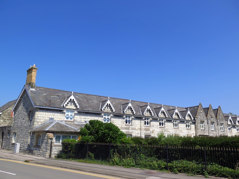
Location: Beside the road close to Ogmore River, the entrance range at right angles facing S across a formal garden.
County: Bridgend
Town: Bridgend
Community: Bridgend (Pen-y-bont ar Ogwr)
Community: Bridgend
Built-Up Area: Bridgend
Traditional County: Glamorgan
Tagged with: Workhouse
Commissioned by the Bridgend & Cowbridge Union, October 1836, completed Autumn 1838. Designed by George Wilkinson, architect of Witney (Oxfordshire). Cost £4,100. Originally to house 200 persons.
Plan form of 3 parallel ranges linked by a spinal range running from rear of S range. 2-storeys, 7-3-5 windows with advanced centre. Blue lias facings, sandstone dressings, slate roofs. Cusped bargeboards with finials to gables over 1st floor windows, 3 steep gables with parapets, kneelers and inscribed cartouche to centre. Plain band courses between storeys, low plinth. Voussoir lintels, 2-light windows with small casements on upper floor, modern frames to ground floor. Pair of stone doorcases to centre with drip stones. Gothic arches and flush-panelled doors.
Single-storey hipped roof extensions over arched entrance at road end.
Modern buildings to right end with 1-storey flat roof extension to S are not of special interest. Western rubble walled 2-storey courtyard survives radiating from 3-storey octagon with splayed ornately gabled angles. Canted single-storey rubble range overlooking road, raised by one storey to S end beside side access to walled courtyard.
External links are from the relevant listing authority and, where applicable, Wikidata. Wikidata IDs may be related buildings as well as this specific building. If you want to add or update a link, you will need to do so by editing the Wikidata entry.


Other nearby listed buildings