Approximate Location Map
Large Map »
Latitude: 51.8027 / 51°48'9"N
Longitude: -4.9697 / 4°58'10"W
OS Eastings: 195343
OS Northings: 215728
OS Grid: SM953157
Mapcode National: GBR CK.XRYV
Mapcode Global: VH1RD.TY2G
Plus Code: 9C3QR23J+34
Entry Name: Haverfordwest Castle
Listing Date: 12 October 1951
Last Amended: 30 November 2005
Grade: I
Source: Cadw
Source ID: 12031
Building Class: Defence
Also known as: Hwlffordd Castle
ID on this website: 300012031
Location: Situated on hill in centre of the town.
County: Pembrokeshire
Town: Haverfordwest
Community: Haverfordwest (Hwlffordd)
Community: Haverfordwest
Built-Up Area: Haverfordwest
Traditional County: Pembrokeshire
Tagged with: Castle
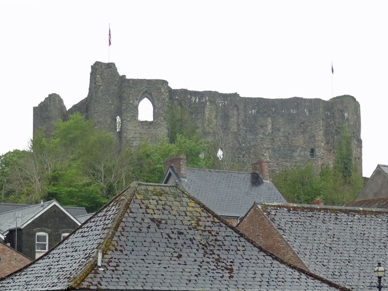
Remnant of C12-13 castle, principally the shell of the great keep with two towers. The castle originally extended much further to both SW and NW, traces of buildings in a wider area have been revealed, for instance behind the SW side of Castle Street, and to the NW, near the NW end of the former County Gaol.
The castle is first mentioned in 1188 by Gerald of Wales, when it was held by Richard Fitz Tancred, whose father, from Flanders, probably founded the castle c. 1110. Robert Fitz Richard was ejected by King John in 1210 and the castle was granted to William Marshal of Pembroke. It was probably rebuilt then. It resisted an attack by forces of Llewelyn the Great in 1220. From the Marshals the castle passed to the de Bohuns, though taken from them 1265-74 for their part in the De Montfort uprising. In 1289 it was exchanged by the de Bohuns with Queen Eleanor, and large sums were spent by her in 1289-90, which may include much of what remains. It was a royal castle thereafter, though granted for life to Aylmer de Valence of Pembroke, 1308-24, to Isabella of France 1331-58, to Thomas de Felton c. 1370-80, John de Clanvowe 1383-91 and Thomas Earl of Worcester 1393-1403. It was attacked but not taken in the Glyndwr uprising 1405. There are records of a tower rebuilt, a new tower at the gate, and a new stable at this time. The pattern of grants to nobles continued in the C15, including William Lord Herbert 1462-69, and Jasper Tudor 1488-95, both Earls of Pembroke. Small works are recorded in 1472 and 1477. By 1577 the castle was in ruins. The remains were slighted in 1648, and the ruins slowly robbed of stone. They are shown more extensive in the 1740 Buck engraving. In 1780 a prison was built within the inner ward, enlarged with a debtors' prison 1816. French prisoners were held here in 1797. These buildings have gone, mostly cleared in the later C20. The surviving former County Gaol in the outer ward dates from 1820.
Ruins of castle, rubble stone. The principal surviving part is the inner ward at the E end of the castle hill, enclosed on three sides by medieval work, the fourth partly open and partly occupied by the Governor's House of 1780 contained the inner gate originally. The surviving high curtain wall has a SW tower to S of the Governor's House and S wall of the former hall with two very large pointed first floor windows of c. 1290. It was raised on an undercroft lit by five lancet windows. The tower has chambers on three levels. At the SE angle was the former chapel with a square tower facing E and big windows to E and S, the E window rebuilt with brick pointed head. The E range is terminated by massively thick walls of a late C12 NE tower. there were two chambers at first floor, the S one with three big late C13 windows, now blocked, and undercroft windows below. The N one has cruder windows with stone voussoirs, three, the N two paired. The outer walls of the NE tower survive, very thick with fireplaces in N wall. A short corbelled wall-passage runs W to the Brechinock Tower with a stub of wall running SE towards the former inner gate. The curtain wall is preserved in part along the N side running W from the Brechinock Tower in a curve overlooking Hayguard Lane, with the bases of a mural tower N of the former Gaol and a square tower N of the car park visible.
Graded I as the substantial remains of a large medieval castle, dominating the town. Scheduled Ancient Monument PE366 (PEM).
External links are from the relevant listing authority and, where applicable, Wikidata. Wikidata IDs may be related buildings as well as this specific building. If you want to add or update a link, you will need to do so by editing the Wikidata entry.


Other nearby listed buildings
