History in Structure

Highway Farmhouse

A Grade II Listed Building in Newport, Pembrokeshire

More Photos »
Approximate Location Map
Large Map »

Coordinates

Latitude: 52.0155 / 52°0'55"N

Longitude: -4.8411 / 4°50'27"W

OS Eastings: 205137

OS Northings: 239043

OS Grid: SN051390

Mapcode National: GBR CR.H1WC

Mapcode Global: VH2MZ.1LLR

Plus Code: 9C4Q2585+6H

Entry Name: Highway Farmhouse

Listing Date: 14 April 1992

Last Amended: 14 April 1992

Grade: II

Source: Cadw

Source ID: 12522

Building Class: Domestic

ID on this website: 300012522

Location: Situated on roadside on W edge of Newport, some 0.5km from centre.

County: Pembrokeshire

Community: Newport (Trefdraeth)

Community: Newport

Built-Up Area: Newport

Traditional County: Pembrokeshire

Tagged with: Farmhouse

Find accommodation in
Dinas

Exterior

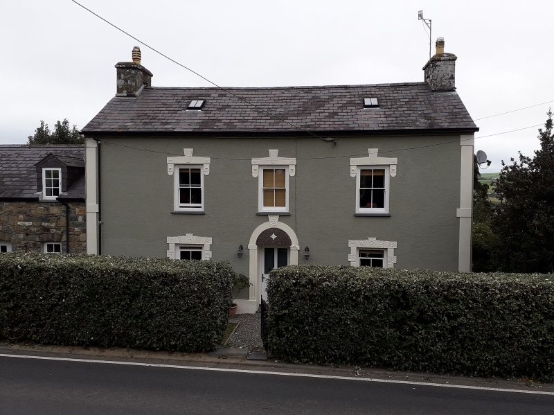
Early C19 farmhouse, front altered later in C19, rubble stone, unpainted rendered front, slate roof and stone end stacks. Two storey three window range of plate glass sashes with centre half-glazed door. Unpainted stucco details (probably C20) include angle piers, labels over upper windows, vermiculated rusticated surrounds below and arch-headed door surround with imposts, key and pebbledashed tympanum, these features very similar to work on houses in Upper West Street (see Westleigh). Rendered E end with loft light.

Rear has projecting stair-gable, arch-headed stair-light above, with glazing bars and traceried head, and sash window below.

Reasons for Listing

Farmhouse is marked on OS map as Pentre House.

External Links

External links are from the relevant listing authority and, where applicable, Wikidata. Wikidata IDs may be related buildings as well as this specific building. If you want to add or update a link, you will need to do so by editing the Wikidata entry.

Recommended Books

Other nearby listed buildings

  • II Mount View
    Situated on roadside immediately E of junction of Ffordd Bedd-Morris.
  • II Gatepiers at Cotham Lodge
    Situated along roadside boundary of Cotham Lodge garden on main approach to Newport from west.
  • II Roadside Wall at Cotham Lodge
    Situated along roadside boundary of Cotham Lodge garden on main approach to Newport from west.
  • II Cotham Lodge
    Detached house situated in own grounds at W edge of town.
  • II Abertawe House, including back cottage
    Towards the west end of the street, on its southern side, immediately west of Westgate.
  • II Trem y don
    Immediately behind (and attached to) Newport Pottery (a former grain warehouse or maltings), fronting a narrow lane which runs west from the west side of Parrog Road.
  • II Gwaunfa
    In an informal terrace on the north side of the main street running through the town, west of the road leading to Parrog.
  • II Westleigh
    Situated in terraced row at W end of Upper West Street.

BritishListedBuildings.co.uk is an independent online resource and is not associated with any government department. All government data published here is used under licence. Please do not contact BritishListedBuildings.co.uk for any queries related to any individual listed building, planning permission related to listed buildings or the listing process itself.

British Listed Buildings is a Good Stuff website.