History in Structure

Chapel Cottages No 1

A Grade II Listed Building in Govilon, Monmouthshire

More Photos »
Approximate Location Map
Large Map »

Coordinates

Latitude: 51.8176 / 51°49'3"N

Longitude: -3.0657 / 3°3'56"W

OS Eastings: 326634

OS Northings: 213754

OS Grid: SO266137

Mapcode National: GBR F3.WQ61

Mapcode Global: VH795.TL40

Plus Code: 9C3RRW9M+2P

Entry Name: Chapel Cottages No 1

Listing Date: 19 October 1994

Last Amended: 15 March 1996

Grade: II

Source: Cadw

Source ID: 14929

Building Class: Domestic

ID on this website: 300014929

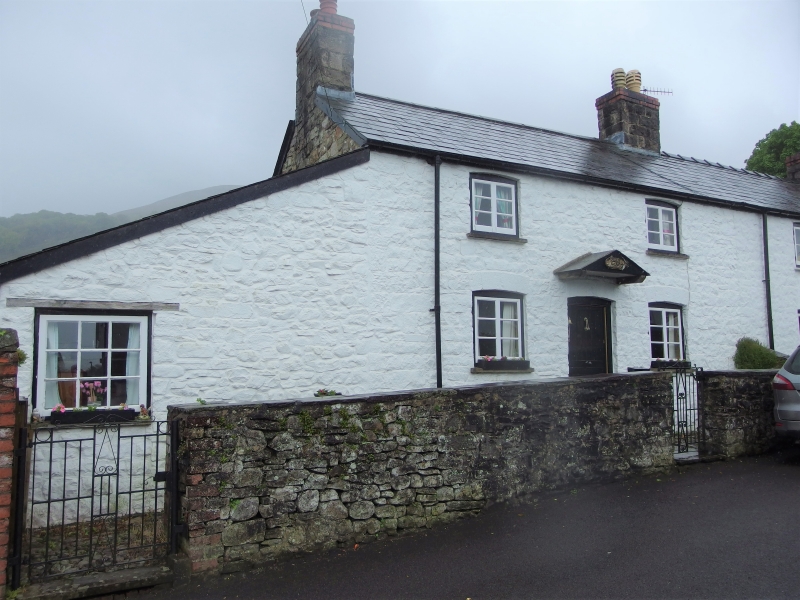
Location: Situated on the edge of the burial ground to Llanwenarth Baptist Church and immediately north of the Monmouthshire and Brecon Canal. Set back behind low rubble forecourt walls including dividing wall

County: Monmouthshire

Community: Llanfoist Fawr (Llan-ffwyst Fawr)

Community: Llanfoist Fawr

Locality: Govilon

Built-Up Area: Govilon

Traditional County: Monmouthshire

Tagged with: Cottage

Find accommodation in
Govilon

History

Early to mid C19 terrace of three cottages. Although known as Chapel Cottages they are more likely to be associated with the history of the Brecknock and Abergavenny Canal (now known as the Monmouthshire and Brecon Canal). This was constructed between 1797 and 1812 and Govilon was an important point on the canal for the local coal and iron industry, as it was the terminus for Bailey's tramroad, opened in 1821, down from Nantyglo Ironworks. It is likely that these are industrial workers cottages dating from this period.

Reasons for Listing

Included as good examples of C19 workers' housing probably associated with the canal and for group value with Llanwenarth Baptist Chapel.

External Links

External links are from the relevant listing authority and, where applicable, Wikidata. Wikidata IDs may be related buildings as well as this specific building. If you want to add or update a link, you will need to do so by editing the Wikidata entry.

Recommended Books

Other nearby listed buildings

  • II Chapel Cottages No 2
    Situated on the edge of the burial ground to Llanwenarth Baptist Church and immediately north of the Monmouthshire and Brecon Canal. Set back behind low rubble forecourt walls including dividing wall
  • II Chapel Cottages No 3
    Situated on the edge of the burial ground to Llanwenarth Baptist Church and immediately north of the Monmouthshire and Brecon Canal. Set back behind low rubble forecourt walls including dividing wall
  • II* Llanwenarth Baptist Church
    Situated near the centre of Govilon in a large burial ground immediately north of the Monmouthshire and Brecon Canal.
  • II Govilon Bridge (Canal Bridge no 98)
    Carrying the village road over the canal to west of Llanwenarth Baptist Chapel.
  • II Govilon House
    At the corner of the main road through Govilon and a side lane up to Station Road.
  • II Derwen Deg
    Set in the slope on the southern side of Govilon, facing a lane off Station Road and sited below the line of the former railway. Set back behind rubble front wall.
  • II Barn to S of Derwen Deg
    Immediately uphill from Derwen Deg to which it is linked by the attached rubble boundary wall. Derwen Deg is on the southern side of Govilon below the line of the former railway.
  • II Railway Viaduct over Canal to SE of Govilon
    Spanning the canal at a skewed angle, to south-east of Govilon.

BritishListedBuildings.co.uk is an independent online resource and is not associated with any government department. All government data published here is used under licence. Please do not contact BritishListedBuildings.co.uk for any queries related to any individual listed building, planning permission related to listed buildings or the listing process itself.

British Listed Buildings is a Good Stuff website.