Approximate Location Map
Large Map »
Latitude: 51.6087 / 51°36'31"N
Longitude: -4.171 / 4°10'15"W
OS Eastings: 249762
OS Northings: 192216
OS Grid: SS497922
Mapcode National: GBR GS.HKWC
Mapcode Global: VH3MQ.NT9N
Plus Code: 9C3QJR5H+FH
Entry Name: Pillory in Llanrhidian Village formed from reputed ancient cross.
Listing Date: 3 June 1964
Last Amended: 20 April 2000
Grade: II
Source: Cadw
Source ID: 15857
Building Class: Civil
ID on this website: 300015857
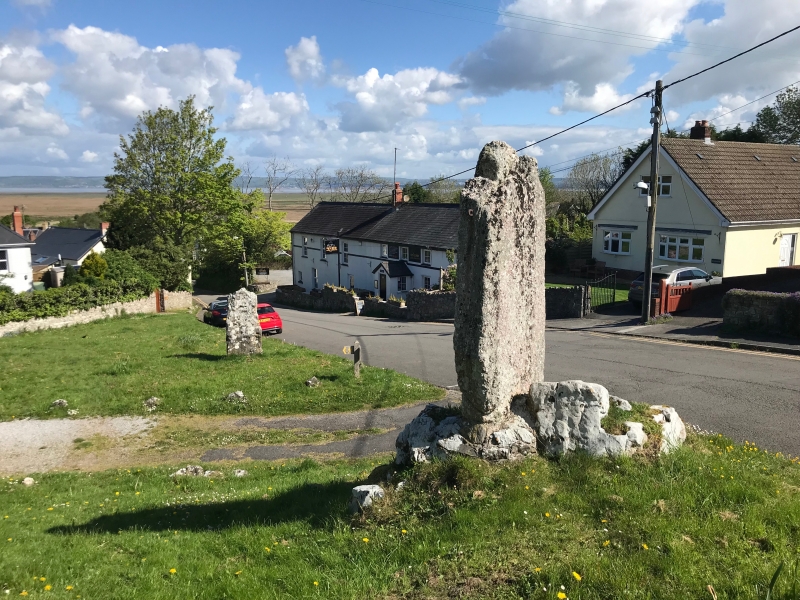
Location: At south side of a path leading from the main street of the village to Llanrhidian parish church. The stone in set in a hollow in a natural rock outcrop.
County: Swansea
Town: Swansea
Community: Llanrhidian Lower (Llanrhidian Isaf)
Community: Llanrhidian Lower
Locality: Llanrhidian village
Built-Up Area: Llanrhidian
Traditional County: Glamorgan
Tagged with: Architectural structure
This appears to replace a preaching cross depicted on a map of 1798. This open central part of the village was known as The Cross, and fairs were held here. Sufficient remains of the head to show this stone was probably intended for a Celtic cross. It is, however, of a type of stone unsuited to carving, the local red sandstone conglomerate of Cefn Bryn. Its former location is unknown but it is thought to have been re-erected in its present position in c1820. Whatever the purpose of its re-erection, it was stated in 1886 that the stone had been used as a village pillory 'within living memory'. Perforated iron inserts were set into the stone at each edge, and have been explained as points to which an offender could be chained. They are too slight and placed too high to have been for tethering animals. Pillories were
abolished for most offences in 1816, before the erection of this stone; but for the offences of perjury and subornation they were permitted to remain until 1837.
A stone measuring about 2m in height, about 1.1m wide by 0.2m thick. The rear face is slightly rounded and the remains of the cross wheel-head are flush on that side; the cross was evidently intended to be seen from one side only in its original location. The stone is now set in a cleft at the top of a small natural limestone outcrop.
The stem of a possible Celtic cross brought from another location, remarkably reused as a pillory at a very late date when such punishments were generally illegal.
External links are from the relevant listing authority and, where applicable, Wikidata. Wikidata IDs may be related buildings as well as this specific building. If you want to add or update a link, you will need to do so by editing the Wikidata entry.


Other nearby listed buildings
