Latitude: 51.9957 / 51°59'44"N
Longitude: -3.2323 / 3°13'56"W
OS Eastings: 315488
OS Northings: 233742
OS Grid: SO154337
Mapcode National: GBR YW.JJVL
Mapcode Global: VH6BV.X3KG
Plus Code: 9C3RXQW9+73
Entry Name: Talgarth Mill
Listing Date: 14 August 1995
Last Amended: 14 August 1995
Grade: II
Source: Cadw
Source ID: 16297
Building Class: Industrial
ID on this website: 300016297
Location: Located on the right bank of the river Enig, about 50m above Talgarth Bridge, with access at the side of the Town Hall.
County: Powys
Community: Talgarth
Community: Talgarth
Built-Up Area: Talgarth
Traditional County: Brecknockshire
Tagged with: Mill
The mill is said to have started as a weaving mill for the production of "brecknocks". Latterly it was used for grinding corn and beans for local farms. The mill ceased operation in 1970, due to charges levied for water "consumed", and the machinery, including two pairs of stones on the stone floor were dismantled and dispersed. One Forest of Dean stone survives ex-situ in an adjoining building.
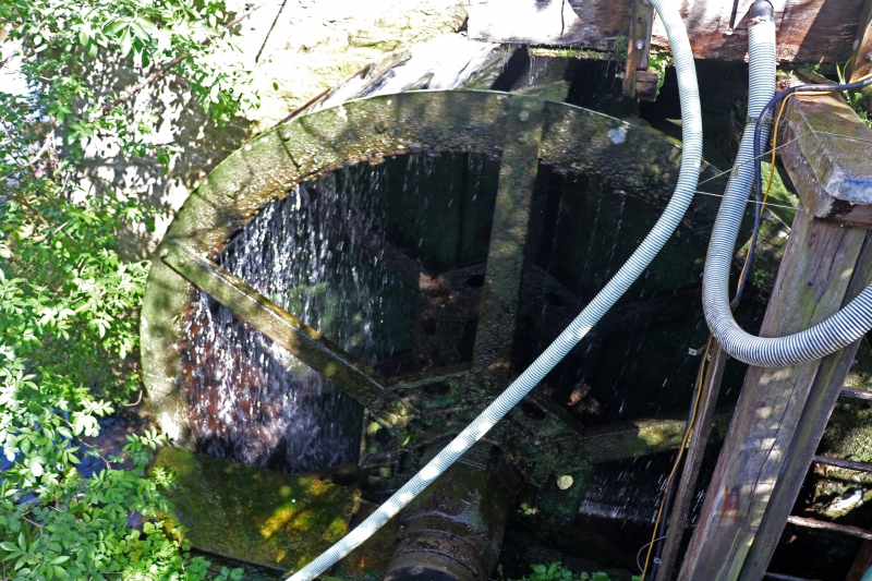
Water operated mill, early-mid C19. Rubble stone building of 3 floors with a stone slated roof. The gable end has double access doors to the lower bin floor, similar doors to the first, the stone floor, and a 2-light casement window lighting the top "hopper" floor. On the S end, an external overshot water wheel with an iron shaft and connecting hub for 5 radial timber spokes connecting to the outer iron ring holding the iron bound rim buckets. Above the wheel, a timber plank box containing a rod-operated sluice controlling the flow of water emerging from the 40cm diameter iron delivery pipe. The pipe drew water from beyond two sluice gates further upstream, and runs at a slight fall parallel to the river, turning into the head box.
No machinery survives.
Included as the sole survivor of an important aspect of the town's industrial past, and for having the unusual arrangement of a 5-spoked wheel. Of group value with the bridge and town hall.
External links are from the relevant listing authority and, where applicable, Wikidata. Wikidata IDs may be related buildings as well as this specific building. If you want to add or update a link, you will need to do so by editing the Wikidata entry.


Other nearby listed buildings