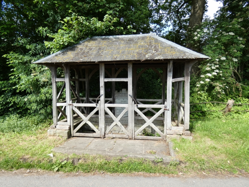
Well house to St Gynidr's Well
A Grade II Listed Building in Glasbury, Powys
Coordinates
Latitude: 52.0636 / 52°3'49"N
Longitude: -3.2207 / 3°13'14"W
OS Eastings: 316411
OS Northings: 241286
OS Grid: SO164412
Mapcode National: GBR YX.D1QR
Mapcode Global: VH6BH.4D6C
Plus Code: 9C4R3Q7H+FP
Entry Name: Well house to St Gynidr's Well
Listing Date: 18 January 1996
Grade: II
Source: Cadw
Source ID: 17202
Building Class: Water Supply and Drainage
ID on this website: 300017202
Location: Located at the E end of the hamlet of Ffynnon Gynnydd, at the corner of the road to Painscastle, set in the road verge.
County: Powys
Community: Glasbury (Y Clas-ar-wy)
Community: Glasbury
Locality: Ffynnon Gynnydd
Traditional County: Radnorshire
Tagged with:
Well
History
St Cynidr was the son of Kehingeyr or Ceingeir, daughter of Brychan, and was probably the patron saint of Glasbury. A pre-Norman church associated with the holy well was probably located nearby and a field across the road opposite is known as Cae Ffynnon. Its former significance was still remembered as a wishing well up to 1949.
External Links
External links are from the relevant listing authority and, where applicable, Wikidata.
Wikidata IDs may be related buildings as well as this specific building. If you want to add or update a link, you
will need to do so by editing the Wikidata entry.
Recommended Books
Other nearby listed buildings
-
II
Farm building at Pen-y-waun farm
The farm is located above and to the S of Cil-Twrch common. The farm building is located immediately behind the late C18-early C19 farmhouse that was largely destroyed by fire in July 1995.
-
I
Cottage attached to Maesyronnen United Reformed Chapel
The chapel and adjoining cottage lie at the end of a lane off the road from the A.438 Hereford to Brecon Road to Ffynnon Gynnydd, near the top of a steep bank and overlooking the Cilcenni Dingle.
-
I
Maesyronnen United Reformed Chapel
The chapel and adjoining cottage lie at the end of a lane off the road from the A.438 Hereford to Brecon Road to Ffynnon Gynnydd, near the top of a steep bank and overlooking the Cilcenni Dingle.
-
II
Maesllwch Castle
Maesllwch Castle stands prominently on a hillside ledge approximately 1 mile N of Glasbury village, providing extensive views over the Wye valley and the Black Mountains of Breconshire. The origina
-
II
East Lodge to Maesllwch Castle
Located at a bend of the minor road leading off the Brecon to Hereford Road to Ffynnon Gynnydd. The lodge stands just within the gates, on the N side of the driveway.
-
II
Gate piers, gates and screen to the E drive of Maesllwch Castle
Located at a bend of the minor road leading off the Brecon to Hereford Road to Ffynnon Gynnydd.
-
II
Granary and carthouse at Penwern farm
The carthouse, with granary over, is located at the end of the farm road, N of the W end of the cowhouse, and by the former cross farm tracks.
-
II
Penwern
Located on the parish boundary between Boughrood and Glasbury parishes, and accessed by farm road from Cornhill. The farmhouse is set at the corner of the farmyard, with cowhouse attached in line, an