History in Structure

Cartshed at Pen-y-Bont

A Grade II Listed Building in Ysbyty Ifan, Conwy

More Photos »
Approximate Location Map
Large Map »

Coordinates

Latitude: 53.0244 / 53°1'27"N

Longitude: -3.7279 / 3°43'40"W

OS Eastings: 284206

OS Northings: 348852

OS Grid: SH842488

Mapcode National: GBR 67.FDY3

Mapcode Global: WH66J.Q71R

Plus Code: 9C5R27FC+QV

Entry Name: Cartshed at Pen-y-Bont

Listing Date: 8 April 1997

Last Amended: 8 April 1997

Grade: II

Source: Cadw

Source ID: 18307

Building Class: Agriculture and Subsistence

ID on this website: 300018307

Location: Adjacent to Pen-y-Bont farmhouse to the NE and facing a small farmyard to the W.

County: Conwy

Community: Ysbyty Ifan

Community: Ysbyty Ifan

Traditional County: Caernarfonshire

Tagged with: Carriage house

Find accommodation in
Yspytty-Ifan

History

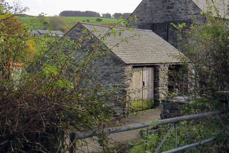
Third-quarter C19 cartshed, built as part of the Pen-y-Bont farm, following the purchase of the Eidda estate by Lord Penrhyn in 1856.

Exterior

Third-quarter C19 cartshed; of rubble construction with medium-pitched slate roof and tiled ridge. 2-bay with large, plain openings to the eaves and a central dividing rubble pier. Catslide addition to the rear at R with recessed boarded door to S face.

Reasons for Listing

Included for group value with other listed items at Pen-y-Bont.

External Links

External links are from the relevant listing authority and, where applicable, Wikidata. Wikidata IDs may be related buildings as well as this specific building. If you want to add or update a link, you will need to do so by editing the Wikidata entry.

Recommended Books

Other nearby listed buildings

  • II Pen-y-Bont Farmhouse
    Adjoining the former inn at the W approach of the Pont Ysbyty Ifan, in a prominent river-side location.
  • II Pen-y-Bont (formerly Penrhyn Arms Inn)
    Prominently located in the centre of the village at the W approach to Pont Ysbyty Ifan.
  • II Agricultural Range at Pen-y-Bont
    Prominently sited at the crossroads at the western end of the village and enclosing a small farmyard behind Pen-y-Bont; facing the B 4407 to the NW and the main Ysbyty Ifan street to the SW.
  • II* Pont Ysbyty Ifan
    Prominently located in the centre of the village and carrying the main road over the Afon Conwy.
  • II Former Privy to Nos 1 and 2 Mill Street
    On the W bank of the river Conwy, at the end of the garden in front of Nos 1-2 Mill Street.
  • II 1, Mill Street, Ysbyty Ifan
    Facing the river Conwy on its W bank in the centre of the village; immediately SW of the Pont Ysbyty Ifan, rubble-walled and gated forecourt.
  • II Former Corn Mill
    Set back slightly at the village crossroads diagonally opposite Pont Ysbyty Ifan.
  • II 2, Mill Street, Ysbyty Ifan
    Facing the river Conwy on its W bank in the centre of the village; immediately SW of the Pont Ysbyty Ifan, rubble-walled and gated forecourt.

BritishListedBuildings.co.uk is an independent online resource and is not associated with any government department. All government data published here is used under licence. Please do not contact BritishListedBuildings.co.uk for any queries related to any individual listed building, planning permission related to listed buildings or the listing process itself.

British Listed Buildings is a Good Stuff website.