History in Structure

Bowden House

A Grade II Listed Building in Abergele, Conwy

More Photos »
Approximate Location Map
Large Map »

Coordinates

Latitude: 53.2839 / 53°17'2"N

Longitude: -3.5829 / 3°34'58"W

OS Eastings: 294564

OS Northings: 377496

OS Grid: SH945774

Mapcode National: GBR 3ZFG.3J

Mapcode Global: WH657.YQ0B

Plus Code: 9C5R7CM8+HR

Entry Name: Bowden House

Listing Date: 5 August 1997

Last Amended: 5 August 1997

Grade: II

Source: Cadw

Source ID: 18663

Building Class: Domestic

ID on this website: 300018663

Location: Chapel Street runs S from the town centre. The house stands 200m S of the junction, before a side entry to the rear.

County: Conwy

Town: Abergele

Community: Abergele

Community: Abergele

Built-Up Area: Abergele

Traditional County: Denbighshire

Tagged with: House

Find accommodation in
Abergele

History

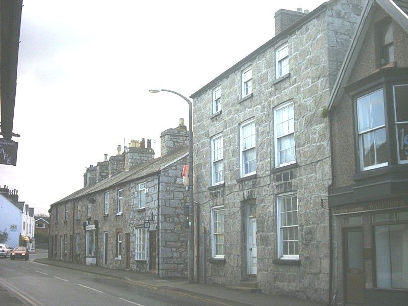
Built c1820 as a substantial town dwelling house.

Exterior

Built of coursed limestone with a slate roof. Three storeys and cellar, 3-bays, symmetrical with gable brick stacks. Central 4-panelled door with decorative overlight, raised 2 steps from the pavement, and 12-pane sashes to either side on ground and first floors. Painted stone sills. The top floor has smaller 9-pane sashes. To the rear, a narrow 2-storey service wing on the N side.

Reasons for Listing

Included as a handsome and unaltered Georgian style town house of architectural quality.

External Links

External links are from the relevant listing authority and, where applicable, Wikidata. Wikidata IDs may be related buildings as well as this specific building. If you want to add or update a link, you will need to do so by editing the Wikidata entry.

Recommended Books

Other nearby listed buildings

  • II Telephone Call-box outside the Harp Inn
    Set into angle of buildings on wide pavement outside the Harp Inn; D L Morgan's Medical Hall stands forward on the right.
  • II Former Medical Hall
    Located to the W of the centre of the town, almost opposite Church Street, stepping forward from the Harp PH immediately E.
  • II Shop adjoining former Medical Hall
    Located to the W of the centre of the town, almost opposite Church Street, stepping forward from the Harp PH immediately E.
  • II National Westminster Bank
    The building stands on the W corner of Church Street, in the centre of the town.
  • II Eglwys Mynydd Seion
    Chapel Street runs S from the centre of the town. The chapel is set on an elevated platform, almost opposite the junction with High Street.
  • II Lych Gate to Church of St Michael
    Church Street leads off Market Street at the centre of the town. The lychgate is at the entrance to the churchyard at the end of the road.
  • II Ty-mawr Terrace
    Small N facing terrace leading W off the junction with Market Place, close to the Parish Church.
  • II Ty-mawr Terrace
    Small N facing terrace leading W off the junction with Market Place, close to the Parish Church.

BritishListedBuildings.co.uk is an independent online resource and is not associated with any government department. All government data published here is used under licence. Please do not contact BritishListedBuildings.co.uk for any queries related to any individual listed building, planning permission related to listed buildings or the listing process itself.

British Listed Buildings is a Good Stuff website.