Approximate Location Map
Large Map »
Latitude: 51.7377 / 51°44'15"N
Longitude: -4.3086 / 4°18'31"W
OS Eastings: 240689
OS Northings: 206855
OS Grid: SN406068
Mapcode National: GBR GP.BRJZ
Mapcode Global: VH3M2.8LK7
Plus Code: 9C3QPMQR+3H
Entry Name: Kidwelly Bridge/Pont Cydweli
Listing Date: 28 July 1998
Last Amended: 28 July 1998
Grade: II
Source: Cadw
Source ID: 20184
Building Class: Transport
ID on this website: 300020184
Location: Situated on main road (A 484) crossing Gwendraeth Fach, between Bridge Street and New Street.
County: Carmarthenshire
Town: Kidwelly
Community: Kidwelly (Cydweli)
Community: Kidwelly
Locality: Kidwelly/Cydweli
Built-Up Area: Kidwelly
Traditional County: Carmarthenshire
Tagged with: Bridge
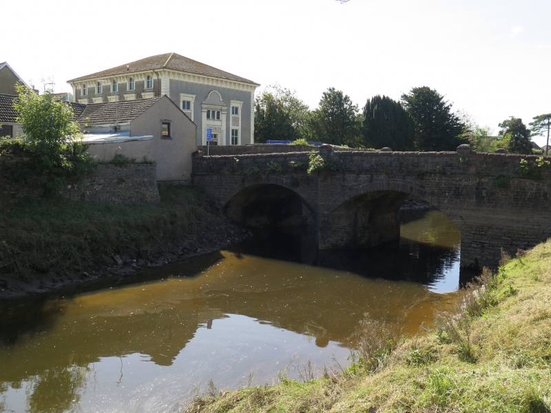
Road bridge over Gwendraeth Fach of three distinct periods, the original narrow bridge of uncertain date possibly late C15, widened twice, the exterior faces and parapets now of c1920-30. A bridge is mentioned by Leland in the C16, described as a handsome stone bridge in 1816 by Rees, this probably the bridge illustrated by Gastineau in the earlier C19 with one round and one pointed arch.
Rubble stone two-arch bridge with early C20 coursed rock-faced rubble facing to both sides, stone voussoirs to segmental arches, string course and parapet. Parapet has tooled limestone coping and four raised piers, each with tooled limestone caps.
Bridge is carried on a big centre pier with large cutwater both sides into which die the arches of the various bridge widenings. Cutwater projects slightly beyond face of final widening and is carried up to just below parapet coping. Underside of bridge shows clearly line of widening both sides. The original S arch is pointed and the N arch rounded, they die into the main part of the centre pier. The widening has been with segmental arches from the cutwater suggesting that possibly the original bridge had cutwaters carried up as pedestrian refuges.
Listed as an early stone bridge, disguised by later alterations.
External links are from the relevant listing authority and, where applicable, Wikidata. Wikidata IDs may be related buildings as well as this specific building. If you want to add or update a link, you will need to do so by editing the Wikidata entry.


Other nearby listed buildings
