Approximate Location Map
Large Map »
Latitude: 52.9313 / 52°55'52"N
Longitude: -3.0556 / 3°3'20"W
OS Eastings: 329140
OS Northings: 337620
OS Grid: SJ291376
Mapcode National: GBR 73.M88P
Mapcode Global: WH89J.1L65
Plus Code: 9C4RWWJV+GQ
Entry Name: Ward Monument in churchyard of the Church of St Mary
Listing Date: 29 July 1998
Last Amended: 29 July 1998
Grade: II
Source: Cadw
Source ID: 20205
Building Class: Religious, Ritual and Funerary
ID on this website: 300020205
Location: The tomb is set 3m S of the S nave wall of the church.
County: Wrexham
Town: Wrexham
Community: Chirk (Y Waun)
Community: Chirk
Built-Up Area: Chirk
Traditional County: Denbighshire
Tagged with: Monument
Erected sometime after 1854. T E Ward was an industrialist, lessee and developer of Black Park Colliery from 1805, owner of the Plas Kinaston brickworks, who laid a tramway to the canal at Rhos-y-waen. Later he established wharves for coal and limestone on the Montgomery Canal at Newtown and Welshpool. John Dicken of Cefn-y-wern, his son-in-law, continued his businesses, including Pen-y-bont brickworks.
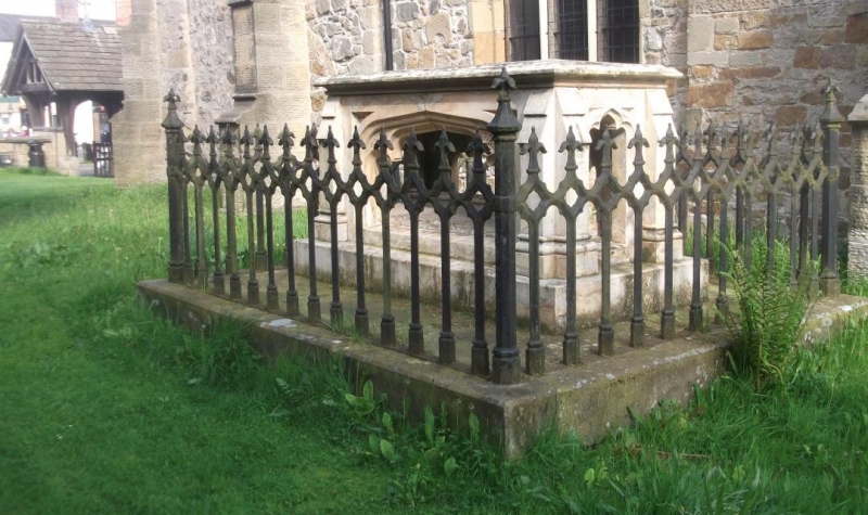
An open chest of painted sandstone, each side with a wide cusped arch and hollow spandrels, set on a base, and with slight buttresses at the corners. Exposed within, a ridged hog-back tomb inscribed on the top to Thomas Edward Ward, died 1854, Edward Lloyd, Harriet etc and the name of John Ward Dicken is carved on the capstone. The whole monument is set on a plinth and surrounded by bold cast iron railings, cross-laced and cusped at the top, and with fleur terminals.
Included as a good example of a mid-Victorian graveyard monument to an important local industrialist, of group value with the church within the Conservation Area.
External links are from the relevant listing authority and, where applicable, Wikidata. Wikidata IDs may be related buildings as well as this specific building. If you want to add or update a link, you will need to do so by editing the Wikidata entry.


Other nearby listed buildings
