Approximate Location Map
Large Map »
Latitude: 53.231 / 53°13'51"N
Longitude: -4.5211 / 4°31'15"W
OS Eastings: 231819
OS Northings: 373409
OS Grid: SH318734
Mapcode National: GBR 56.0D6X
Mapcode Global: WH42X.J19V
Plus Code: 9C5Q6FJH+CH
Entry Name: Surf Point
Listing Date: 7 September 1998
Last Amended: 7 September 1998
Grade: II
Source: Cadw
Source ID: 20425
Building Class: Domestic
ID on this website: 300020425
Location: Located at the coast, overlooking Traeth Crigyll. Surfpoint is reached by a single track lane off the W side of the A4080, Station Road, in N Rhosneigr.
County: Isle of Anglesey
Community: Llanfaelog
Community: Llanfaelog
Locality: Rhosneigr
Built-Up Area: Rhosneigr
Traditional County: Anglesey
Tagged with: Building
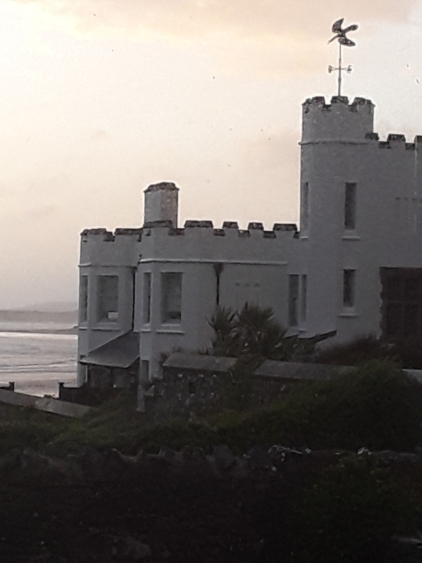
The house was built 1906-8 for the sausage manufacturer, C H Palethorpe, of Tipton, Worcestershire.
A castellated seaside 'folly' style house; a light-heartedly designed holiday home built to resemble a large sandcastle at the seashore. Assymmetrically planned; the main block square in plan with octagonal towers at the seaward facing angles, an additional rectangular block extending from the NE corner. Continuing south-eastwards from the SE corner of this rectangular block is a castellated wall which returns in a northeasterly direction to form 2 sides of a yard with lean-to verandahs and outbuildings along the inner sides of the shielding walls and a small pitched roof hut in the centre. The principal elevations of the house are the NW and SW elevations of the 2-storey, square block, which face out to sea. Both elevations have a continuous, stressed string above the first floor windows and octagonal towers at each corner; windows are slightly recessed sashes with single paned lower lights and small paned upper lights. The NW elevation has similarly detailed windows between the towers, 3 windows to the ground floor and 2 windows to the first floor flanked by small circular fixed lights. The SW elevation has a single ground floor window towards the SW tower; the towers are linked by a slate-roofed verandah on timber supports. There is a rectangular stack to the SE which is slightly advanced over a lombard frieze; left of the stack the castellated parapet steps upwards by 3 steps, echoed by detailing on the wall below. The SE elevation of the square block returns to meet the rectangular block and has a single window to the ground floor, the first floor with 3 mock arrow slits. The SW elevation of rectangular block has a single first floor window at its NW end, right of this window is an advanced block formed by 3 sides of a tall stair tower illuminated by tall, narrow, small paned lights to each of 3-storeys; the ground floor is a further advanced square block with a slate roof and 2 round-headed lights. The SE return beyond the stair tower has a first floor transomed and mullioned window of 3-lights, upper lights with stained glass windows depicting sailing ships; the storey above has 5 mock arrow slits. The SW elevation of the rectangular block then continues as a 2-window range with ground floor, slate-roofed verandah. The NE elevation of the square block is a mirror of the SW elevation, with tower at the corner and opposing chimney stack. The elevation is then advanced as the NE elevation of the rectangular block; the NW part with single window to ground and first floors, central part with 2 ground floor windows and 4 narrower first floor windows, the SE part with single ground floor at SE end and wider ground floor window to right. Beyond the SE end of the rectangular block is a yard; a wall extends from the SE corner and returns NE, with entrance through a segmental headed panelled door under a segmental arched porch on rubble piers; the returning wall with castellated parapet stepped upwards in the centre and at the angles. The inner walls of this yard have lean-to outbuildings and slate-roofed verandahs along their lengths; a small pitched roof outbuilding extending from the lean-to at the SE end. The entrance to the house is at the landward side, through 2 gateways, each with square, rubble piers surmounted by rendered caps and globe finials. The gates are wooden, the bottom part with some slats pierced, the upper part with spaced slats under a top rail descending to the centre. The grounds are enclosed by low rubble walls. The formality of the composition is enhanced by consistently detailed crenellation and whitened roughcast renderd walls throughout.
The entrance leads to an outer hallway, the inner hallway beyond with contemporary dog-leg staircase with battered newels and splat balusters, some pierced. At the turn in the stairs is the transomed and mullioned window, the upper parts with stained glass windows depicting sailing ships, the lower windows decorated by stained glass panes of fishes. A doorway enters the staircase to the roof, this is illuminated by tall, narrow windows each with coloured glass bearing inscriptions of a nautical nature. Below the main staircase is a doorway leading to the basement below. The principal ground floor rooms face seawards, the service rooms to the rear. The principal rooms retain the original fireplaces with brick surrounds, window seats in the octagonal towers and all rooms retain original panelled doors. The bathroom upstairs retains the tiling and original fixtures and fittings.
Listed as a striking example of an early C20 seaside home (reflecting the development of the area as a resort), an unusual, idiosyncratic design, planned and detailed for picturesque effect.
External links are from the relevant listing authority and, where applicable, Wikidata. Wikidata IDs may be related buildings as well as this specific building. If you want to add or update a link, you will need to do so by editing the Wikidata entry.


Other nearby listed buildings
