History in Structure

Pont Rhydlydan

A Grade II Listed Building in Pentrefoelas, Conwy

More Photos »
Approximate Location Map
Large Map »

Coordinates

Latitude: 53.0433 / 53°2'35"N

Longitude: -3.6531 / 3°39'11"W

OS Eastings: 289265

OS Northings: 350836

OS Grid: SH892508

Mapcode National: GBR 6B.D72S

Mapcode Global: WH66C.VRLT

Plus Code: 9C5R28VW+8P

Entry Name: Pont Rhydlydan

Listing Date: 19 October 1998

Last Amended: 19 October 1998

Grade: II

Source: Cadw

Source ID: 20582

Building Class: Transport

ID on this website: 300020582

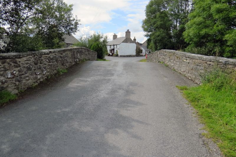
Location: The bridge is in the middle of the hamlet of Rhydlydan, carrying the S road to Pentrefoelas over the Afon Merddwr.

County: Conwy

Town: Pentrefoelas

Community: Pentrefoelas

Community: Pentrefoelas

Locality: Rhydlydan

Traditional County: Denbighshire

Tagged with: Bridge Road bridge

Find accommodation in
Pentrefoelas

History

The bridge was built in 1815 by Edward Jones and John Lloyd to replace an earlier bridge of 1711 on the same site, itself possibly replacing the ford of the placename. The date of 1815 on the bridge suggests there was a delay in execution of the contract drawn up in 1810.

Exterior

Rubble stonework. A single segmental arch spanning c10.9m between low abutments over the Afon Merddwr, comprising a single ring of 0.5m deep voussoirs set back under a projecting regulating course, without a central keystone, 3.4m above water level. Flush spandrels and parapet, which turns sharply to end in square piers. Flush copings. The carriageway is humped, 5.7m wide between the 0.5m thick parapets. On the inside of the parapet a datestone reading EI ILL 1815.

Reasons for Listing

Included as a fine and dated example of the type of country bridge widely erected in the late C18 and early C19 in North Wales.

External Links

External links are from the relevant listing authority and, where applicable, Wikidata. Wikidata IDs may be related buildings as well as this specific building. If you want to add or update a link, you will need to do so by editing the Wikidata entry.

Recommended Books

Other nearby listed buildings

  • II Pont Twllaran
    The bridge adjoins the A5 Holyhead Road immediately N of the hamlet of Rhydlydan and carries the minor road to Cwm Llwm.
  • II Hendre-Brys, with attached farm buildings
    The farm lies 550m SW of Rhydlydan, near the farm road to Plas Iolyn, and is reached by a farm track off the road running S.
  • II Former farmhouse at Penrhyn
    Penrhyn lies 600m S of Rhydlydan, and is accessed by a farm road leading off the road to Bala.
  • II Bethel Addoldy yr Annibynwyr including Ty-capel, Schoolroom and associated teacher's house
    The group of attached buildings is set on a T-junction on the road from Rhydlydan to Pentrefoelas, approximately 600m W of Rhydlydan.
  • II Bryn-heilyn
    Bryn-Heilyn is located 650m down a farm road which branches off the Cwm Llwm Road NE of Rhydlydan. It is set on a sloping site, with stable opposite and farm yard to the E.
  • II Stable Building at Bryn-heilyn
    The farm lies along a farm track between the Cwm Llwm Road N of Rhydlydan and Cwrt-y-llyn. The stable faces the farmhouse across the road.
  • II Castell
    The house was originally one of a group of 3 on a low stony plateau bounded on the N by the Afon Merddwr, and is reached by a trackway from opposite Capel Bethel Rhydlydan.
  • II Outbuilding at Plas Iolyn
    The building stands apart, E of the house, on sloping ground, now the garden, and near the approach drive.

BritishListedBuildings.co.uk is an independent online resource and is not associated with any government department. All government data published here is used under licence. Please do not contact BritishListedBuildings.co.uk for any queries related to any individual listed building, planning permission related to listed buildings or the listing process itself.

British Listed Buildings is a Good Stuff website.