History in Structure

Pont Twllaran

A Grade II Listed Building in Pentrefoelas, Conwy

More Photos »
Approximate Location Map
Large Map »

Coordinates

Latitude: 53.0449 / 53°2'41"N

Longitude: -3.653 / 3°39'10"W

OS Eastings: 289277

OS Northings: 351011

OS Grid: SH892510

Mapcode National: GBR 6B.D73B

Mapcode Global: WH66C.VQNL

Plus Code: 9C5R28VW+WQ

Entry Name: Pont Twllaran

Listing Date: 19 October 1998

Last Amended: 19 October 1998

Grade: II

Source: Cadw

Source ID: 20583

Building Class: Transport

ID on this website: 300020583

Location: The bridge adjoins the A5 Holyhead Road immediately N of the hamlet of Rhydlydan and carries the minor road to Cwm Llwm.

County: Conwy

Town: Pentrefoelas

Community: Pentrefoelas

Community: Pentrefoelas

Locality: Rhydlydan

Traditional County: Denbighshire

Tagged with: Bridge Road bridge

Find accommodation in
Pentrefoelas

History

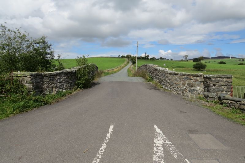
The bridge was built in 1806 to a contract with Owen David of Llangwam (Llangwm?) dated 6th November 1805, for completion on 10.7.1806. The contract is signed by Thomas Penson, engineer, who was probably the designer.

Exterior

Rubble stonework. A single segmental arch spanning c7.2m between low abutments over the Afon Merddwr, comprising a single ring of voussoirs set back under a projecting regulating course, without a central keystone, 2.77m above water level. Flush spandrels and parapet, which bends outwards at the ends to terminate in square piers. Flush stone copings. The carriageway is humped, 4.5m wide between the 0.5m thick parapets.

Reasons for Listing

Included as a conspicuous and well preserved bridge typical of the type built in the late C18 and early C19 throughout much of N Wales.

External Links

External links are from the relevant listing authority and, where applicable, Wikidata. Wikidata IDs may be related buildings as well as this specific building. If you want to add or update a link, you will need to do so by editing the Wikidata entry.

Recommended Books

Other nearby listed buildings

  • II Pont Rhydlydan
    The bridge is in the middle of the hamlet of Rhydlydan, carrying the S road to Pentrefoelas over the Afon Merddwr.
  • II Bethel Addoldy yr Annibynwyr including Ty-capel, Schoolroom and associated teacher's house
    The group of attached buildings is set on a T-junction on the road from Rhydlydan to Pentrefoelas, approximately 600m W of Rhydlydan.
  • II Hendre-Brys, with attached farm buildings
    The farm lies 550m SW of Rhydlydan, near the farm road to Plas Iolyn, and is reached by a farm track off the road running S.
  • II Former farmhouse at Penrhyn
    Penrhyn lies 600m S of Rhydlydan, and is accessed by a farm road leading off the road to Bala.
  • II Bryn-heilyn
    Bryn-Heilyn is located 650m down a farm road which branches off the Cwm Llwm Road NE of Rhydlydan. It is set on a sloping site, with stable opposite and farm yard to the E.
  • II Stable Building at Bryn-heilyn
    The farm lies along a farm track between the Cwm Llwm Road N of Rhydlydan and Cwrt-y-llyn. The stable faces the farmhouse across the road.
  • II Castell
    The house was originally one of a group of 3 on a low stony plateau bounded on the N by the Afon Merddwr, and is reached by a trackway from opposite Capel Bethel Rhydlydan.
  • II Outbuilding at Plas Iolyn
    The building stands apart, E of the house, on sloping ground, now the garden, and near the approach drive.

BritishListedBuildings.co.uk is an independent online resource and is not associated with any government department. All government data published here is used under licence. Please do not contact BritishListedBuildings.co.uk for any queries related to any individual listed building, planning permission related to listed buildings or the listing process itself.

British Listed Buildings is a Good Stuff website.