Approximate Location Map
Large Map »
Latitude: 51.9003 / 51°54'1"N
Longitude: -3.7686 / 3°46'6"W
OS Eastings: 278413
OS Northings: 223895
OS Grid: SN784238
Mapcode National: GBR Y5.QHVQ
Mapcode Global: VH5FH.MHKL
Plus Code: 9C3RW62J+4H
Entry Name: Blaensawdde
Listing Date: 10 November 1998
Last Amended: 10 November 1998
Grade: II
Source: Cadw
Source ID: 20823
Building Class: Domestic
ID on this website: 300020823
Location: Situated up long drive running E from bridge over the Mirhartach towards the bottom of lane running S from Llanddeusant church.
County: Carmarthenshire
Town: Llangadog
Community: Llanddeusant
Community: Llanddeusant
Traditional County: Carmarthenshire
Tagged with: House
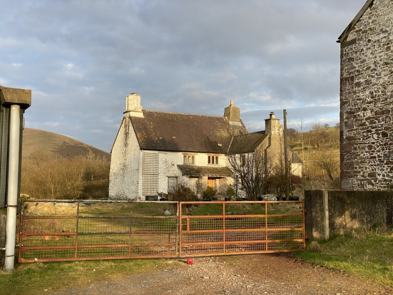
Gentry house of the C17, in present character though perhaps earlier in origin the home of the Edwards family from the C17 into early C18 (Rees Edwards 1632-1720 was High Sheriff in 1714). Passed to the Gwyn family by a marriage in 1715. Howel Gwyn MP (1806-88) of Dyffryn, Neath, inherited in 1830. The Tithe map of 1841 shows a holding of 92 acres ( 37.3ha) occupied by Gwen Davies. Howel Gwyn paid for the restoration of the parish church in 1885 and was the last of the family to own Blaensawdde. A map of 1744 shows a picture of the house with diagonal chimneys and features reminiscent of the present house but difficult to reconcile precisely. The post and panel partition was the only one recorded in the county in Peter Smith's inventory.
House, whitewashed rendered rubble stone with slate roofs and roughcast stacks. Two storeys. Main range with large paired diagonal stack at N end, square stack at S end. S end has lower wings extending in 3 directions, giving a rough cruciform plan. Main range has 2 first floor C20 casement pairs under thin stone C17 hoodmoulds, one to centre, one centre left, over a ground floor slate-roofed 2-bay lean-to or pentice of whitewashed walls and stone roof. Plank door is in right bay. To left of pentice is 12-pane window. N end wall is blank. To right of door projects W wing which has external W end stack rebuilt in C20. Narrow plan, one first floor C20 9-pane window and half-glazed door to N front. Rear of this wing has one C20 window. Beyond main S chimney is lower S wing with square rubble stone S end stack and one 4-pane sash to W front. C20 window in S end wall. East side of S wing has C20 window in original opening, recently revealed. Rear of main house has curved projection, probably of former mural stair, in SE corner, then projecting E wing which is windowless to S, has C20 E end window with gable rebuilt in brick, and one side window. To right, rear of main range has 12-pane window to ground floor centre and two blocked windows to first floor and ground floor blocked window next to curved projection.
Two-room plan to main range, entrance hall formerly divided from room to N by a post-and-panel partition, now gone. Large N end fireplace with stone stairs to right. The S end chimney backs onto the entry and is open into the third main ground floor room, in the S wing, suggesting that this may have been an earlier part. The E and W wings are narrow, presumably service wings. Main range has modern stairs facing entry, where the previous ones were dog-leg in rear corner. Large chamfered ceiling beam with run-out stops. Ovolo-moulded timber doorcase to door into E wing. N end room has fielded panelled C18 door, fireplace is infilled, main beam clad, beam against fireplace on corbels. S end room has very deep chimney with heavy oak lintel, chamfered, run-out stop to left, right end covered over. First floor has exposed woven hazel partition by stairs, and fine post and panel partition, the posts broad and scratch moulded. Doorway at left end, blocked doorway at right end. Chamfered beams. Blocked window in rear wall with chamfered timber lintel and ogee stops. Fielded 2-panel door into rear wing and deep recess to E of S chimney wall. Roof has 3 oak collar trusses and double purlins, some replaced.
Included as an important surviving gentry house of the C17, with rare surviving post-and-panel partition.
External links are from the relevant listing authority and, where applicable, Wikidata. Wikidata IDs may be related buildings as well as this specific building. If you want to add or update a link, you will need to do so by editing the Wikidata entry.


Other nearby listed buildings
