Approximate Location Map
Large Map »
Latitude: 53.0283 / 53°1'41"N
Longitude: -4.1292 / 4°7'45"W
OS Eastings: 257302
OS Northings: 350006
OS Grid: SH573500
Mapcode National: GBR 5P.FCFG
Mapcode Global: WH556.J4XS
Plus Code: 9C5Q2VHC+88
Entry Name: Pont Rhyd-ceffylau
Listing Date: 25 November 1998
Last Amended: 25 November 1998
Grade: II
Source: Cadw
Source ID: 20927
Building Class: Transport
ID on this website: 300020927
Location: Located towards the western boundary of the community within the Beddgelert forest and spanning the Afon Hafod-Ruffydd-Isaf; approximately 0.5km W of the A 4085, carrying the pre-turnpike road.
County: Gwynedd
Town: Porthmadog
Community: Beddgelert
Community: Beddgelert
Locality: Beddgelert Forest
Traditional County: Caernarfonshire
Tagged with: Bridge Road bridge
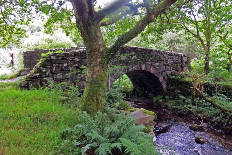
Single-span road bridge, rebuilt after floods in 1844.
Of rubble construction with segmental arch and rough-dressed voussoirs. Humped, unmetalled carriageway with rough, uncoped parapets, apparently slightly raised. These are splayed out slightly at the approaches and have square terminating piers.
Adjoining on both sides of the stream on the upstream side are the boulder platforms of an earlier bridge.
Listed for its special interest as a late C18 or early C19 regional road bridge retaining good character.
External links are from the relevant listing authority and, where applicable, Wikidata. Wikidata IDs may be related buildings as well as this specific building. If you want to add or update a link, you will need to do so by editing the Wikidata entry.


Other nearby listed buildings
