Approximate Location Map
Large Map »
Latitude: 52.995 / 52°59'42"N
Longitude: -4.0962 / 4°5'46"W
OS Eastings: 259411
OS Northings: 346242
OS Grid: SH594462
Mapcode National: GBR 5R.H7H4
Mapcode Global: WH557.1ZQB
Plus Code: 9C4QXWW3+2G
Entry Name: Bridge House (aka Ty Bont)
Listing Date: 25 November 1998
Last Amended: 25 November 1998
Grade: II
Source: Cadw
Source ID: 20940
Building Class: Domestic
ID on this website: 300020940
Location: Located directly opposite the Pont Aberglaslyn, on the road side.
County: Gwynedd
Town: Porthmadog
Community: Beddgelert
Community: Beddgelert
Locality: Pont Aberglaslyn
Traditional County: Caernarfonshire
Tagged with: House
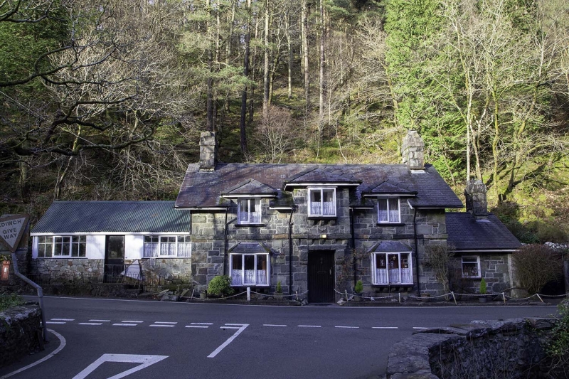
Mid C19 house, built for the Aberglaslyn estate in the characteristic Tudorbethan vernacular style commonly employed for such contemporary estate buildings.
Lodge-scale house with later additions. Two-storey, 3-bay, with lower one-bay wing set back to the R. Of randomly-coursed, roughly-squared stone blocks under a modern slate roof with deep verges and eaves; plain modern bargeboards and simple end chimneys. Central entrance with boarded door. Above this is a first-floor projecting bay carried on shaped corbels and with hipped roof; rectangular projecting oriel, again corbelled, and with plain glazing. Flanking the entrance on the ground floor are similar corbelled bays with hipped slate roofs; above these are first-floor dormer windows with hipped roofs. A plain stringcourse projects between the ground and first floors. The lower wing to the R has an end chimney and a modern window to the front, contained within a primary opening.
A C20 corrugated iron addition adjoins to the L.
The interior was not inspected at the time of survey.
Listed as a mid C19 estate house of distinctive rustic design in a prominent road-side location.
Group value with Pont Aberglaslyn.
External links are from the relevant listing authority and, where applicable, Wikidata. Wikidata IDs may be related buildings as well as this specific building. If you want to add or update a link, you will need to do so by editing the Wikidata entry.


Other nearby listed buildings
