Latitude: 53.1461 / 53°8'45"N
Longitude: -3.4898 / 3°29'23"W
OS Eastings: 300452
OS Northings: 362026
OS Grid: SJ004620
Mapcode National: GBR 6J.5YJZ
Mapcode Global: WH662.C6F0
Plus Code: 9C5R4GW6+C3
Entry Name: Agricultural Range immediately S of Glasmor
Listing Date: 15 December 1998
Last Amended: 15 December 1998
Grade: II
Source: Cadw
Source ID: 20987
Building Class: Agriculture and Subsistence
ID on this website: 300020987
Location: Prominently located at the crossroads at the southern end of the village, opposite Glasmor.
County: Denbighshire
Town: Denbigh
Community: Nantglyn
Community: Nantglyn
Traditional County: Denbighshire
Tagged with: Architectural structure
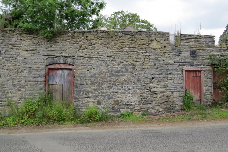
Agricultural range built in 1762 to serve the adjacent farm of Glasmor and unusual in its village setting. The range has a stone date plaque with the incised initials RWM and the date 1762. It originated as a stables with hay-loft over and appears subsequently to have been extended by 2 bays to the L in the C19.
Rectangular agricultural range consisting of a primary section to the R and a later (or rebuilt) section adjoining flush to the L. Of rubble construction, the primary part of coursed, rough-dressed local slate-stone; continuous slated roof, recently renewed. The primary section has 2 entrances to the L with pegged wooden frames and boarded doors. That to the L is lower and has an exposed wooden lintel. Above this is an inset slate plaque inscribed with the date 1762 and the initials RMW. Under the eaves are two small 2-light, unglazed windows with wooden frames. At the far R is an upper, wooden- framed entrance, with stone-stepped access. The left-hand section has a segmentally-arched entrance with slate-stone voussoirs and a pegged oak frame; boarded door. A later C19 lean-to adjoins the L gable end, with a low boarded and framed entrance to the road side.
Plain rear with large corrugated iron doors to the lean-to section. The rear wall of the later section was found to have partly collapsed at the time of survey.
Four-bay interior with original pegged oak raking strut trusses and plain joisted ceiling.
Listed for its special interest as a dated mid C18 stable range forming part of a village farm group in an unusual village setting.
Group value with Glasmor.
External links are from the relevant listing authority and, where applicable, Wikidata. Wikidata IDs may be related buildings as well as this specific building. If you want to add or update a link, you will need to do so by editing the Wikidata entry.


Other nearby listed buildings