Latitude: 51.9136 / 51°54'49"N
Longitude: -3.2756 / 3°16'32"W
OS Eastings: 312357
OS Northings: 224668
OS Grid: SO123246
Mapcode National: GBR YV.PL3H
Mapcode Global: VH6C7.55PB
Plus Code: 9C3RWP7F+FQ
Entry Name: Paragon Tower
Listing Date: 17 December 1998
Last Amended: 17 December 1998
Grade: II
Source: Cadw
Source ID: 21177
Building Class: Gardens, Parks and Urban Spaces
ID on this website: 300021177
Location: High on the mountainside of Allt-yr-Esgair E of Newton. Reached by track from Tal-y-bryn to E.
County: Powys
Community: Talybont-on-Usk (Tal-y-bont ar Wysg)
Community: Talybont-on-Usk
Locality: Llansantffraed
Traditional County: Brecknockshire
Tagged with: Architectural structure
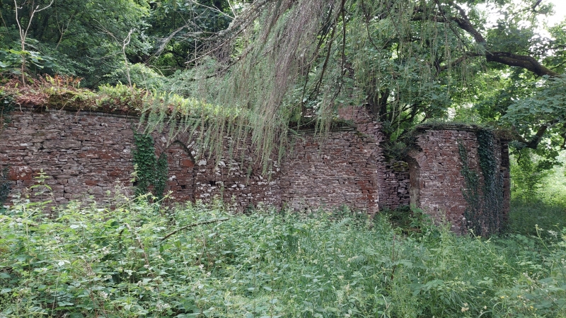
Probably built early - mid C19 as a folly and as a focus for riding, hunting or walking expeditions. It is likely to have been associated with the large Buckland Estate but as the Gwynne Holfords also had nearer lands to the east it is equally possible that it related to Treholford which was built in 1796 and enlarged in 1837. Plan as at present on Tithe of 1841.
A circular building, no longer complete, of stone rubble with dressed stone dressings; joist holes are evidence of a former timber roof. Large central circular chimney with narrow stringcourse and a circular external wall, the space between divided by angled walls into 4 wedge-shaped rooms each with a fireplace. These are low and with narrow voussoirs with the chimney breast above curving outwards; above are angled joist holes. Dividing walls do not meet the external wall allowing a circuit walk just inside; external walls have pointed arched entrance doorways, some still complete, some blocked, the main entrance group of 3 facing W all retain their heads; signs of former internal and external lime render. Extending to right is a slightly curved wall and damaged entrance to a now ruinous roughly rectangular wing. To left a longer wall with a more pronounced curve with blind archway - apparently an original feature - extends towards a separate rectangular building standing roughly to wallplate and gable level with dividing internal ground floor wall. To rear is a ruined retaining wall to the hillside terrace on which this building complex stands.
Included as the remains of an unusual earlier C19 recreational building with picturesque connotations.
External links are from the relevant listing authority and, where applicable, Wikidata. Wikidata IDs may be related buildings as well as this specific building. If you want to add or update a link, you will need to do so by editing the Wikidata entry.


Other nearby listed buildings