Latitude: 51.4855 / 51°29'7"N
Longitude: -3.6099 / 3°36'35"W
OS Eastings: 288315
OS Northings: 177508
OS Grid: SS883775
Mapcode National: GBR HC.KLQ9
Mapcode Global: VH5HJ.CXZM
Plus Code: 9C3RF9PR+53
Entry Name: Nicholl family tomb in churchyard of St Teilo, Merthyr Mawr
Listing Date: 29 January 1999
Last Amended: 29 January 1999
Grade: II
Source: Cadw
Source ID: 21246
Building Class: Commemorative
ID on this website: 300021246
Location: On the SE side of the church, near the E boundary of the churchyard.
County: Bridgend
Community: Merthyr Mawr
Community: Merthyr Mawr
Traditional County: Glamorgan
Tagged with: Tomb
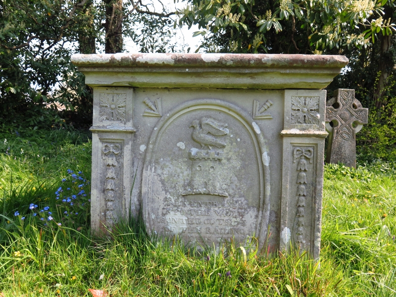
Family tomb built for Sir John Nicholl (1759-1838) of Merthyr Mawr House. The tomb was originally surrounded by railings, which were removed at an unknown date.
A stone table tomb with flat capstone. The angles have pilasters with husks below 4-leaf flowers. On the short sides are oval tablets with the Nicholl family crest (a castle surmounted by a cornish chough) with heraldic pheons upper R and L. On the E side is raised lettering commemorating the family of the Right Honorable Sir John Nicholl. The long sides have wide oval tablets left blank (designed for commemorative inscriptions to be added later), with foliage upper R and L.
An important component of the surviving buildings associated with Sir John Nicholl at Merthyr Mawr, and for group value with the church of St Teilo and other associated listed items.
External links are from the relevant listing authority and, where applicable, Wikidata. Wikidata IDs may be related buildings as well as this specific building. If you want to add or update a link, you will need to do so by editing the Wikidata entry.


Other nearby listed buildings