Latitude: 52.9229 / 52°55'22"N
Longitude: -4.2791 / 4°16'44"W
OS Eastings: 246876
OS Northings: 338595
OS Grid: SH468385
Mapcode National: GBR 5H.MYVJ
Mapcode Global: WH44D.7SKM
Plus Code: 9C4QWPFC+58
Entry Name: Gwynfryn Lodge
Listing Date: 31 March 1999
Last Amended: 31 March 1999
Grade: II
Source: Cadw
Source ID: 21580
Building Class: Domestic
ID on this website: 300021580
Location: The lodge stands at the S end of the long drive to Plas Gwynfryn, 500m W of Llanystymdwy village.
County: Gwynedd
Town: Criccieth
Community: Llanystumdwy
Community: Llanystumdwy
Traditional County: Caernarfonshire
Tagged with: Gatehouse
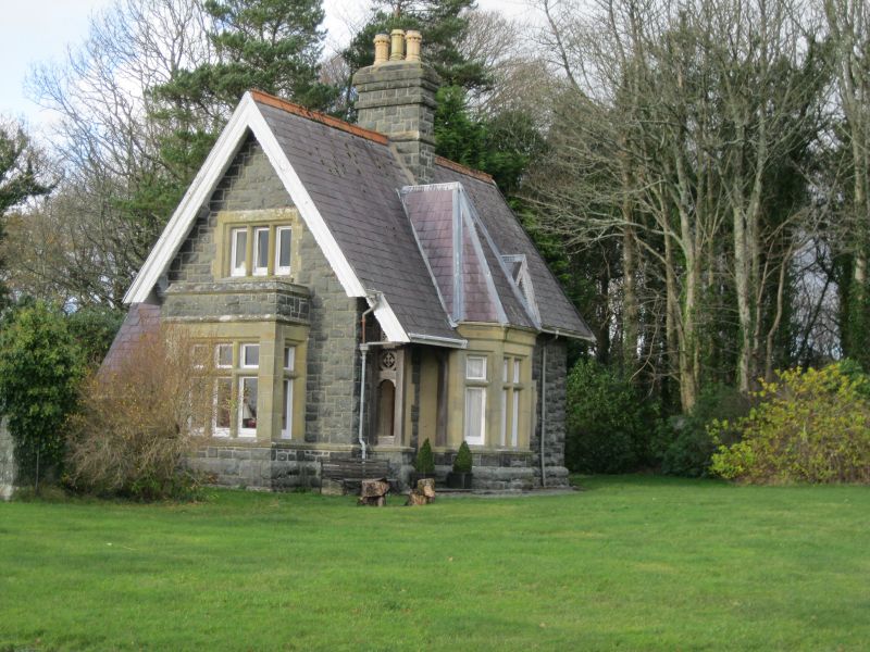
The lodge was built c1880 for the new building of Plas Gwynfryn.
Built of snecked square rockfaced rubble with ashlar dressings and a slate roof capped with red clayware roll ridge tiles. One storey and attic, a long N-S block with a short off-centre cross wing projecting to the E as a canted bay with pyramidal roof, and to the rear for services. Boarded door at the S end of the E front, set within a timber-framed porch, under an extension of the roof. Perforated spandrels. N of the canted front wing, a large dormer. At the S gable end, a square bay window with a stone parapet. Decorative bargeboards. Central stack with string and outsetting head. The rear wing roof is set lower than the N-S range, swept low to the S, and it has a C20 flat roofed extension in similar stone.
Included as a carefully designed asymmetrical picturesque composition, with good detail, an attractive example of a Tudor Gothic park lodge.
External links are from the relevant listing authority and, where applicable, Wikidata. Wikidata IDs may be related buildings as well as this specific building. If you want to add or update a link, you will need to do so by editing the Wikidata entry.


Other nearby listed buildings