Approximate Location Map
Large Map »
Latitude: 51.6518 / 51°39'6"N
Longitude: -3.1691 / 3°10'8"W
OS Eastings: 319217
OS Northings: 195427
OS Grid: ST192954
Mapcode National: GBR HY.73LC
Mapcode Global: VH6DG.1R02
Plus Code: 9C3RMR2J+P9
Entry Name: New Bethel Chapel
Listing Date: 31 March 1999
Last Amended: 31 March 1999
Grade: II
Source: Cadw
Source ID: 21626
Building Class: Religious, Ritual and Funerary
Also known as: New Bethel Independent Chapel
ID on this website: 300021626
Location: On the long hill road leading to Mynyddislwyn church, on the rural hillside overlooking the Sirhowy valley.
County: Caerphilly
Community: Pontllanfraith (Pontllan-fraith)
Community: Pontllanfraith
Locality: Mynyddislwyn
Traditional County: Monmouthshire
Tagged with: Chapel
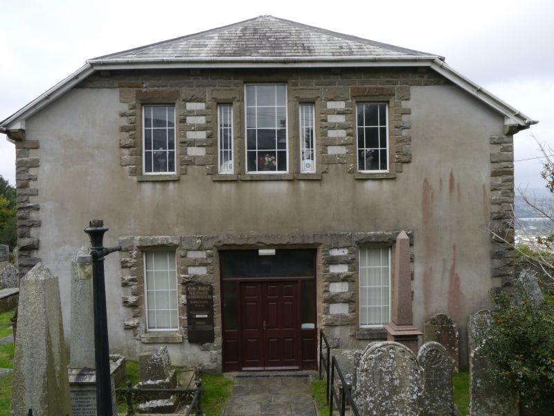
Built 1765, rebuilt 1855. In C17 some inhabitants from Mynyddislwyn reputedly travelled to meetings at Llanvaches (SE Gwent), the first Independent church in South Wales. Cause founded in this district in 1640 and Penmaen the first chapel built 1693. Bethel was built on land leased from Jones family and first minister Revd Thomas Waters - a nephew of the same name succeeded him. Siloh in Gelli-groes, a daughter church, was founded 1811 and other nearby chapels were established by members. In 1847 Sunday and Day School established across lane ( now in Newbridge Community]. New church in 1855 took the name New Bethel. Substantial refurbishing in 1892-6, including new seating. Road metalled and electricty supplied in 1923. Variously described as Independent, Congregational, currently Welsh Reformed.
Chapel aligned E/W with entrance E and interior facing W. Of stone mostly rendered but with rockfaced dressings; Welsh slate roof half-hipped over gable end facade. This has at gallery level a tripartite central window and one each side, the rock-faced surrounds combining to form a pattern across the range. Window glazing all modern replacements. Ground floor is similar with very wide central doorway with double doors and flanking windows all under adjoining rock-faced lintels; rockfaced quoins also. Similar windows and rendered buttresses to sides; long paired windows with rockfaced and tooled surrounds to rear.
Interior retains gallery, with panelled front and boarded soffit, cast iron columns, boarded hallway with stairs each side to gallery, grained woodwork; original ceiling covered. On the wall are plaques to former ministers including that to founder Thomas Waters (d 1794) in English and Welsh; he was buried in the cemetery by the rear wall but the church was extended over his grave which now lies under the pulpit; plaque also to Rev Thomas Harries of Kidwelly (d 1837); some other plaques re-sited from former Jerusalem chapel Blackwood.
Listed notwithstanding unsympathetic modern alterations for its importance as the centre of this small mid C18 hillside settlement comprising the Sunday School opposite and a fine range of tombs and headstones set within a walled graveyard.
External links are from the relevant listing authority and, where applicable, Wikidata. Wikidata IDs may be related buildings as well as this specific building. If you want to add or update a link, you will need to do so by editing the Wikidata entry.


Other nearby listed buildings
