Approximate Location Map
Large Map »
Latitude: 53.1252 / 53°7'30"N
Longitude: -4.1343 / 4°8'3"W
OS Eastings: 257282
OS Northings: 360796
OS Grid: SH572607
Mapcode National: GBR 5P.7466
Mapcode Global: WH54M.GQH1
Plus Code: 9C5Q4VG8+37
Entry Name: Ynys-wen
Listing Date: 28 May 1999
Last Amended: 28 May 1999
Grade: II
Source: Cadw
Source ID: 21855
Building Class: Domestic
ID on this website: 300021855
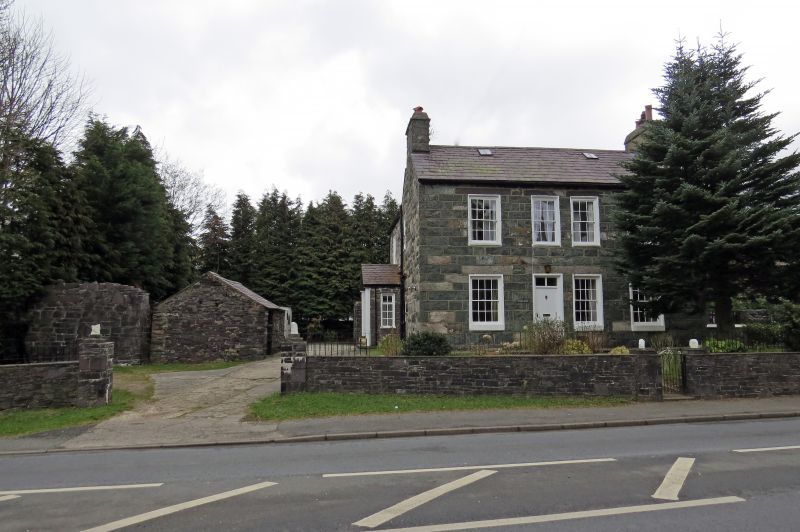
Location: Located on the north-east side of the A 4086 approximately 0.5km north-west of Llanberis; set directly onto the pavement behind a snecked rubblestone wall with C20 iron railings to top.
County: Gwynedd
Town: Caernarfon
Community: Llanberis
Community: Llanberis
Locality: LLanberis
Built-Up Area: Llanberis
Traditional County: Caernarfonshire
Tagged with: Farmhouse
Shown on the 1838 Tithe Map, the farmhouse is likely to have been built in the 1820s or '30s.
Farmhouse. 2-storey L-plan with rear range at right-angles to left, continued behind to form single-storey service range. Regularly coursed and dressed rubblestone blocks to front, more roughly coursed to sides and rear; slate roofs with rooflights. 4-window front; recessed 16-paned sashes throughout with slate lintels to first floor and stone lintels to ground floor, except 2 closely spaced 12-paned sashes to centre on first floor; 4-panel door in second bay from left; integral end stacks with slate drips, right pebbledashed. Rear range, also with integral end stack, has glazed door with overlight in C20 gabled porch; single-storey service range behind has large integral end stack with tall brick shaft.
Interior not inspected at time of Survey.
Listed as a substantially unaltered early C19 farmhouse with polite features but exhibiting many of the characteristics of the local vernacular tradition; occupies a prominent roadside position.
External links are from the relevant listing authority and, where applicable, Wikidata. Wikidata IDs may be related buildings as well as this specific building. If you want to add or update a link, you will need to do so by editing the Wikidata entry.


Other nearby listed buildings
