Latitude: 53.1091 / 53°6'32"N
Longitude: -3.4052 / 3°24'18"W
OS Eastings: 306029
OS Northings: 357800
OS Grid: SJ060578
Mapcode National: GBR 6N.81BP
Mapcode Global: WH77F.N3NV
Plus Code: 9C5R4H5V+JW
Entry Name: Pont Cyffylliog
Listing Date: 17 June 1999
Last Amended: 17 June 1999
Grade: II
Source: Cadw
Source ID: 21870
Building Class: Transport
ID on this website: 300021870
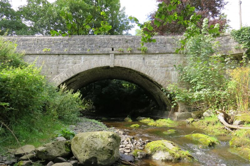
Location: Spanning the Afon Clywedog in the village centre, close to the school.
County: Denbighshire
Community: Cyffylliog
Community: Cyffylliog
Traditional County: Denbighshire
Tagged with: Bridge Road bridge
Village road bridge, in its present form probably early C19, though occupying an early bridging site.
Single-span road bridge constructed of squared, rough-dressed limestone blocks; approximately 15m long. Segmental arch with projecting voussoirs and large keystone. Flat carriageway with rubble parapets, splayed at the approaches and terminating on both up- and down-stream sides in square piers; squared limestone copings. Between the arch and the parapet on both sides is a plain projecting string-course, returned onto the piers.
Listed for its special interest as an early C19 village bridge retaining good character.
External links are from the relevant listing authority and, where applicable, Wikidata. Wikidata IDs may be related buildings as well as this specific building. If you want to add or update a link, you will need to do so by editing the Wikidata entry.


Other nearby listed buildings