History in Structure

Church House

A Grade II Listed Building in Beaufort, Blaenau Gwent

More Photos »
Approximate Location Map
Large Map »

Coordinates

Latitude: 51.7884 / 51°47'18"N

Longitude: -3.2038 / 3°12'13"W

OS Eastings: 317064

OS Northings: 210656

OS Grid: SO170106

Mapcode National: GBR YX.YKY8

Mapcode Global: VH6CV.F94V

Plus Code: 9C3RQQQW+9F

Entry Name: Church House

Listing Date: 30 July 1999

Last Amended: 30 July 1999

Grade: II

Source: Cadw

Source ID: 22135

Building Class: Domestic

ID on this website: 300022135

Location: Set above small walled garden on E side of main road, between Swn-y-Gan and High Trees.

County: Blaenau Gwent

Community: Badminton

Community: Beaufort

Locality: Newchurch

Traditional County: Monmouthshire

Tagged with: House

Find accommodation in
Ebbw Vale

History

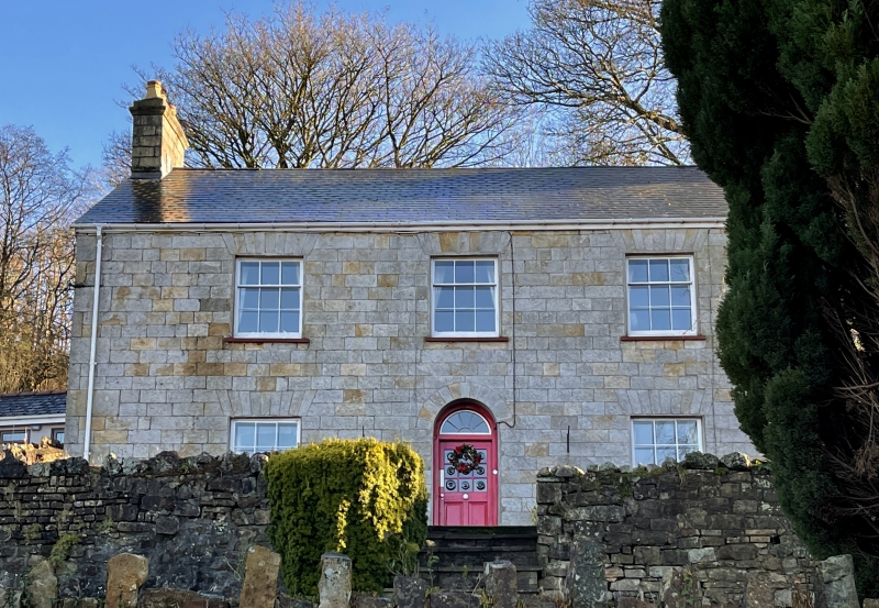
Early/mid C19, possibly contemporary with the demolished St. John’s Church, which stood immediately upslope of the house to the SE. The church was built in 1842 under the patronage of Crawshay Bailey and Co. for families working at the ironworks.

Exterior

Symmetrical facade of three bays and two storeys. Construction of local coursed ashlar blocks. Slate roof. Gable chimneys of ashlar. Central round-arched doorway with radiating fanlight and C20 door. Ground floor 6/6-pane sashes; 3/6 pane sashes to first floor. Windows have flat heads with ashlar voussoirs.

Interior

Not inspected at the time of survey.

Reasons for Listing

Listed as a well-designed and constructed early C19 house, its character well-preserved.

External Links

External links are from the relevant listing authority and, where applicable, Wikidata. Wikidata IDs may be related buildings as well as this specific building. If you want to add or update a link, you will need to do so by editing the Wikidata entry.

Recommended Books

Other nearby listed buildings

  • II Ebenezer Presbyterian Chapel, including New Cottage
    Chapel prominently located in the centre of Pontygof, NE of Ebbw Vale town centre. New Cottage occupies part of chapel building, entered on E side.
  • II Ebbw Vale War Memorial
    Occupies wedge-shaped iron-railed plot on fork of Libanus Road and Steelworks Road.
  • II Newtown Bridge
    Carries road from Ebbw Vale town centre NE to Newtown, over Steelworks Road. E bridge spans Steelworks Road, W bridge carries lesser road S to The Crescent.
  • II Mount Pleasant Stores
    Located on W side of Mount Pleasant Road, the eighth house from the N end of its terrace.
  • II* Furnace Bank
    Set back from the E side of Steelworks Road, to rear of factory buildings, and opposite the main entrance to Ebbw Vale Steelworks.
  • II* British Steel Tinplate Works General Office
    Prominently located along Steelworks Road, on E fringe of massive steelworks complex.
  • II Carmel Independent Chapel
    Prominently located on the W side of Church Crescent, within a small graveyard.

BritishListedBuildings.co.uk is an independent online resource and is not associated with any government department. All government data published here is used under licence. Please do not contact BritishListedBuildings.co.uk for any queries related to any individual listed building, planning permission related to listed buildings or the listing process itself.

British Listed Buildings is a Good Stuff website.