History in Structure

Ebbw Vale War Memorial

A Grade II Listed Building in Ebbw Vale, Blaenau Gwent

More Photos »
Approximate Location Map
Large Map »

Coordinates

Latitude: 51.7831 / 51°46'59"N

Longitude: -3.2075 / 3°12'26"W

OS Eastings: 316800

OS Northings: 210076

OS Grid: SO168100

Mapcode National: GBR YX.YYV8

Mapcode Global: VH6CV.CF5W

Plus Code: 9C3RQQMV+72

Entry Name: Ebbw Vale War Memorial

Listing Date: 29 October 1999

Last Amended: 29 October 1999

Grade: II

Source: Cadw

Source ID: 22528

Building Class: Commemorative

ID on this website: 300022528

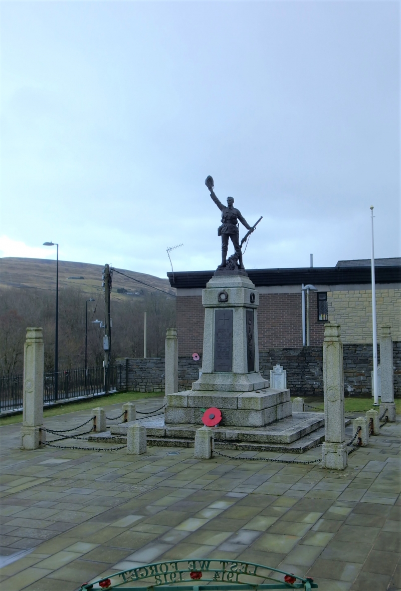
Location: Occupies wedge-shaped iron-railed plot on fork of Libanus Road and Steelworks Road.

County: Blaenau Gwent

Community: Ebbw Vale North (Gogledd Glynebwy)

Community: Ebbw Vale

Built-Up Area: Ebbw Vale

Traditional County: Monmouthshire

Tagged with: Statue War memorial

Find accommodation in
Ebbw Vale

History

Unveiled September 24th 1924 by Sir Frederick Mills. Made by the Craftsmen’s Guild, London.

Exterior

Construction of grey granite. Tall tapering pedestal with concave base, and tall bronze plaques each side with inscriptions. Plain cornice with bronze laurel-wreaths; then above is bronze figure of a soldier triumphantly waving his tin hat (see similar figure at Abertillery). Pedestal stands on tall slightly stepped plinth, two shallow steps below. Square enclosure with tall granite corner posts with sunken panels and bulbous terminals, originally capped with global lanterns (removed). Corner posts are linked to intervening low pylonic granite posts by two rows of chain-link.

Reasons for Listing

Listed as an unusually elaborate war memorial, in a prominent setting.

External Links

External links are from the relevant listing authority and, where applicable, Wikidata. Wikidata IDs may be related buildings as well as this specific building. If you want to add or update a link, you will need to do so by editing the Wikidata entry.

Recommended Books

Other nearby listed buildings

  • II Ebenezer Presbyterian Chapel, including New Cottage
    Chapel prominently located in the centre of Pontygof, NE of Ebbw Vale town centre. New Cottage occupies part of chapel building, entered on E side.
  • II Newtown Bridge
    Carries road from Ebbw Vale town centre NE to Newtown, over Steelworks Road. E bridge spans Steelworks Road, W bridge carries lesser road S to The Crescent.
  • II* Furnace Bank
    Set back from the E side of Steelworks Road, to rear of factory buildings, and opposite the main entrance to Ebbw Vale Steelworks.
  • II Mount Pleasant Stores
    Located on W side of Mount Pleasant Road, the eighth house from the N end of its terrace.
  • II Church House
    Set above small walled garden on E side of main road, between Swn-y-Gan and High Trees.
  • II* British Steel Tinplate Works General Office
    Prominently located along Steelworks Road, on E fringe of massive steelworks complex.
  • II Ebbw Vale Adult Education Centre
    Occupies wide frontage on W side of Church Street, opposite Penuel Chapel. Set behind shallow forecourt.
  • II Penuel Scout Hall (formerly Penuel CM Chapel)
    Located on the E side of Church Street, opposite Adult Education Centre. Set within own plot, behind railed forecourt.

BritishListedBuildings.co.uk is an independent online resource and is not associated with any government department. All government data published here is used under licence. Please do not contact BritishListedBuildings.co.uk for any queries related to any individual listed building, planning permission related to listed buildings or the listing process itself.

British Listed Buildings is a Good Stuff website.