History in Structure

Garn Limekiln No. IV (southernmost in group)

A Grade II Listed Building in Llanfihangel Aberbythych, Carmarthenshire

More Photos »
Approximate Location Map
Large Map »

Coordinates

Latitude: 51.8253 / 51°49'31"N

Longitude: -4.0475 / 4°2'50"W

OS Eastings: 258991

OS Northings: 216062

OS Grid: SN589160

Mapcode National: GBR DT.W0PX

Mapcode Global: VH4J8.SDM1

Plus Code: 9C3QRXG3+42

Entry Name: Garn Limekiln No. IV (southernmost in group)

Listing Date: 27 August 1999

Last Amended: 27 August 1999

Grade: II

Source: Cadw

Source ID: 22190

Building Class: Industrial

ID on this website: 300022190

Location: At the south of a group of four surviving kilns 100m east of the A476, reached by a short lane 200m south of Eglwys Fair, Carmel.

County: Carmarthenshire

Town: Llanelli

Community: Llanfihangel Aberbythych

Community: Llanfihangel Aberbythych

Locality: Carmel Woods

Traditional County: Carmarthenshire

Tagged with: Lime kiln

Find accommodation in
Carmel

History

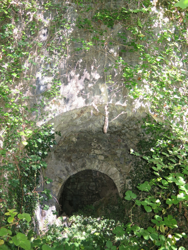
One of several limekilns at this location in c1876-85. It was disused by 1906.
The landholding was a part of the Cawdor estate named Tir-y-garn (based on Garn farmhouse, 300m south-east).

Exterior

A fine single limekiln in rubble limestone masonry. About 8m in width, about 5m high. Straight front wall with a slight curve at left. Segmental main arch over the working area. Two kiln working holes with rough arch to the left, lintel to the right, separated by a thin pier of masonry.
The top has collapsed but the interior diameter was about 4m.
Remnant of a stone hut, 2m by 3m, 50m to the north, on the opposite side of the path.

Reasons for Listing

One of the better-surviving limekilns in an area of intensive C19 and C20 quarrying and lime-burning industry; one of an important surviving contemporary group.

External Links

External links are from the relevant listing authority and, where applicable, Wikidata. Wikidata IDs may be related buildings as well as this specific building. If you want to add or update a link, you will need to do so by editing the Wikidata entry.

Recommended Books

Other nearby listed buildings

  • II Garn Limekiln No. III (3rd from north in group)
    Near the middle of a group of four surviving kilns 100m east of the A476, reached by a short lane 200m south of Eglwys Fair, Carmel. Quarry to the east.
  • II Garn Limekiln No. II (2nd from north in group)
    Near the middle of a group of four surviving kilns 100m east of the A476, reached by a short lane 200m south of Eglwys Fair, Carmel. Quarry to the east.
  • II Garn Limekiln No. I (northernmost in group)
    The northern of a group of four surviving kilns 100m east of the A476, reached by a short lane commencing 200m south of Eglwys Fair, Carmel. Quarry to the east.
  • II Bwlchau Limekiln
    At west side of a footpath 100m north of Bwlchau farmhouse. Quarry to the west.
  • II Pwll-y-march Limekilns
    200m south of the Carmel to Pant-y-llyn road; Pair of limekilns in one structure at east of Pwll-y-march quarry, reached from the road by a path opposite Caeffwrn.
  • II Bantwen
    About 150m west of the road junction in Carmel Village. The cottage stands in a small enclosure behind two later houses.
  • II Pant-y-garn Limekiln No. I (to west)
    200m south of the Carmel to Pant-y-llyn road; reached by a side path east from a lane opposite Caeffwrn. South of its quarry.
  • II Pant-y-garn Limekiln No. II (to east)
    150m south of the Carmel to Pant-y-llyn road; reached by a lane commencing midway between Pwll-y-march and Lletty-mawr. Quarry to north.

BritishListedBuildings.co.uk is an independent online resource and is not associated with any government department. All government data published here is used under licence. Please do not contact BritishListedBuildings.co.uk for any queries related to any individual listed building, planning permission related to listed buildings or the listing process itself.

British Listed Buildings is a Good Stuff website.