Approximate Location Map
Large Map »
Latitude: 51.7969 / 51°47'48"N
Longitude: -3.259 / 3°15'32"W
OS Eastings: 313276
OS Northings: 211664
OS Grid: SO132116
Mapcode National: GBR YV.XXZW
Mapcode Global: VH6CT.G3GB
Plus Code: 9C3RQPWR+QC
Entry Name: Milgatw
Listing Date: 14 October 1999
Last Amended: 14 October 1999
Grade: II*
Source: Cadw
Source ID: 22494
Building Class: Domestic
ID on this website: 300022494
Location: Blaen-y-cwm is reached off the Tredegar-Trefil Road, from Nant-y-bwch. Located some 1 km N of Tredegar. Milgatw is located at the end of the no-through road.
County: Blaenau Gwent
Community: Tredegar
Community: Tredegar
Locality: Blaen-y-cwm
Built-Up Area: Tredegar
Traditional County: Brecknockshire
Tagged with: Building
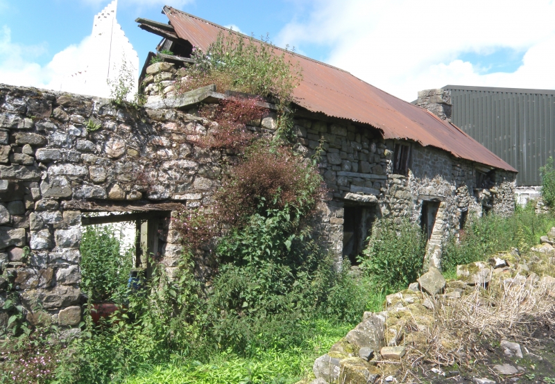
C16-C17, said to have medieval origins. The C16 house seems to have consisted of a chimney-entry plan, with hall and perhaps a small parlour. In the C17, the house was much enlarged, including the addition of an upper floor, and the lengthening of the parlour end to form an unusually large parlour with its own chimney stair. The long downslope byre is clearly an addition, possibly of the C18, forming a cross-passage, superseded in the C19, when, typically, the house was given a centralised doorway. House and parallel outbuilding shown on 1846 Tithe Map.
Rubble construction, with areas of drystone masonry. Traces of limewash. House faces east, set behind small walled garden, with cowhouse to S having pitched stone yard in front. Corrugated iron roof, with some thatch intact underneath. Large square rubble built chimneys to each end of house: larger to S, both set on plinths, with dripmoulds. Smaller rubble chimney towards upper end of cowhouse, serving bread oven, inserted in later C19. Front of house is of four bays, separated by straight masonry joint from cowhouse. Panelled door towards centre with timber lintel. 3-over-6 sash window to left with stone lintel: above, set between latter and door is window with two-light casement, including a diamond mullion (probably not C17). Upper two bays are clearly later, demarcated by masonry joint. Two ground floor windows, first floor window overhead: timber lintels and derelict glazing. Front elevation of lofted cowhouse is of five bays. Window to left, replacing earlier door. Two doors to right, with cross-passage door to right end. Most doors have been renewed.
Ground level raised to rear of house. Two blocked windows to left with projecting stone drips. Small-paned window to right with timber lintel. To the right, the wall projects for chimney stair in hall. Area of wall around cross passage door has collapsed. Door to rear of cowhouse.
Slate flags to ground floor. Large chamfered beams. Hall has chimney stair to right of wide fireplace which has C19 iron range and timber mantel. Cross-passage door to left of fireplace has four-centred chamfered timber frame, visible from cowhouse. Large parlour with chimney stair to left of fireplace. Roof has rough oak A-frames (not fully inspected). Condition deteriorating at the time of survey (June 1999).
Listed as a very rare survival in the industrialised Monmouthshire Valleys of a substantial C16-C17 upland farmhouse, with much of its character intact. Of the relatively few early vernacular farmhouses in the area, few have survived in such instructively unaltered form.
External links are from the relevant listing authority and, where applicable, Wikidata. Wikidata IDs may be related buildings as well as this specific building. If you want to add or update a link, you will need to do so by editing the Wikidata entry.


Other nearby listed buildings
