History in Structure

The Bell House

A Grade II Listed Building in Corris, Gwynedd

We don't have any photos of this building yet. Why don't you be the first to send us one?

Upload Photo »

Approximate Location Map
Large Map »

Coordinates

Latitude: 52.6731 / 52°40'22"N

Longitude: -3.8202 / 3°49'12"W

OS Eastings: 277024

OS Northings: 309926

OS Grid: SH770099

Mapcode National: GBR 93.4Q2Q

Mapcode Global: WH687.923L

Plus Code: 9C4RM5FH+6W

Entry Name: The Bell House

Listing Date: 6 December 1999

Last Amended: 6 December 1999

Grade: II

Source: Cadw

Source ID: 22718

Building Class: Industrial

ID on this website: 300022718

Location: The building stands isolated but close to the road at the N end of the village.

County: Gwynedd

Town: Machynlleth

Community: Corris

Community: Corris

Locality: Aberllefenni

Traditional County: Merionethshire

Tagged with: House

Find accommodation in
Aberllefenni

History

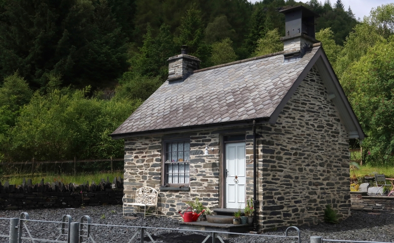
Built in 1880s as the office for Aberllefenni Slate Quarry, a major slab quarry of early origins, but still operated on a small scale.

Exterior

The building is of cut slate laid on bed, roofed with lozenge ended slates and a cut stone half-round ridge. Single storey. Boarded door approached by a square and two monolithic semi-circular steps of slate, and a large single window facing SE. Gutter fascia board. At the NE end, the gable wall rises as a slate bell tower built of slabwork, and still retains the timing bell. At the SW end there is a slate stack serving the internal fireplace.

Interior

The roof is torched.

Reasons for Listing

Included as a significant and distinctive building directly associated with the slate industry, of major importance to the area.

External Links

External links are from the relevant listing authority and, where applicable, Wikidata. Wikidata IDs may be related buildings as well as this specific building. If you want to add or update a link, you will need to do so by editing the Wikidata entry.

Recommended Books

Other nearby listed buildings

  • II* Plas Aberllefenni
    The house stands at the N end of Aberllefenni, in a loop of the road running to the E to Aberangell.
  • II Water Balanced Incline and Drumhouse
    Aberllefenni quarry lies on the NW branch road leading off the Aberllefenni to Aberangell road. The incline lies back c150m SW of the road.
  • II Cymerau Cottages
    The row of four cottages is set back fromt he track, near the S end of the road running up Cwm Ratgoed, and backs on to Cymerau Quarry.
  • II Cymerau Cottages
    The row of four cottages is set back from the track at the S end of the road running up Cwm Ratgoed, and backs on to Cymerau Quarry.
  • II Cymerau Cottages
    The row of four cottages is set back from the track at the S end of the road running up Cwm Ratgoed, and backs on to Cymerau Quarry.
  • II Cymerau Cottages
    The row of 4 cottages is set back from the track at the S end of the road running up Cwm Ratcoed, and backs on to Cymerau Quarry.
  • II Hen-gau
    The farmhouse is located on the W side of the valley under Fron-fawr, facing E with farm buildings set apart to the N and S. It is reached by a farm track leading off the main valley road running NW

BritishListedBuildings.co.uk is an independent online resource and is not associated with any government department. All government data published here is used under licence. Please do not contact BritishListedBuildings.co.uk for any queries related to any individual listed building, planning permission related to listed buildings or the listing process itself.

British Listed Buildings is a Good Stuff website.