Approximate Location Map
Large Map »
Latitude: 51.6471 / 51°38'49"N
Longitude: -3.9856 / 3°59'8"W
OS Eastings: 262713
OS Northings: 196126
OS Grid: SS627961
Mapcode National: GBR WKD.ZQ
Mapcode Global: VH4K2.VVTP
Plus Code: 9C3RJ2W7+VP
Entry Name: Capel Bethlehem including attached vestry block
Listing Date: 7 January 2000
Last Amended: 7 January 2000
Grade: II
Source: Cadw
Source ID: 22775
Building Class: Religious, Ritual and Funerary
Also known as: Bethlehem Independent Chapel
ID on this website: 300022775
Location: Set back from the A483 S of its junction with Carmarthen Road, and sited within a large burial ground.
County: Swansea
Town: Swansea
Community: Cockett (Y Cocyd)
Community: Cockett
Locality: Fforest-fach
Built-Up Area: Swansea
Traditional County: Glamorgan
Tagged with: Chapel
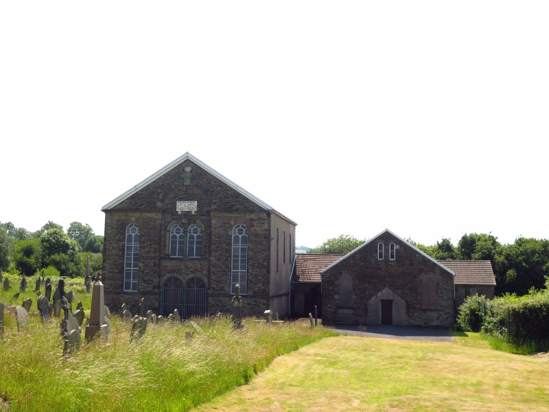
The first chapel here was built in 1840, its mother chapel being at Mynyddbach. The present building was built in 1866, with an increased seating capacity of 650, by William Humphreys, the minister-architect who also designed Cwmbwrla Chapel and Horeb Chapel in Loughor. Humphreys was minister at Bethlehem from 1851 to 1868. The attached vestry was a later addition.
A classical style chapel of coursed rock-faced stone and rusticated dressings, and a replaced tile roof. The 3 bay gable end front has a central bay recessed beneath a glorification arch that breaks through the cornice of a pedimented gable. The openings in the central bay have ashlar dressings, moulded capitals and keystones. A pair of round-headed doorways has double panelled doors. Above this is a pair of round-headed windows with geometrical tracery and a sill band. A tablet under the glorification arch is in white marble on 2 moulded corbels and records the date of the building in engraved letters. The outer bays have tall round-headed windows with similar tracery and sill bands. Beneath the apex is a small vented oculus.
The 3-window L side wall is roughcast and has a sill band and round-headed windows. The rear has a lower gabled pebble-dashed projection housing the deacon's room. The R side wall has similar openings to the L side. Attached at the rear is a low wing behind the later vestry and school room, which is T-shaped in plan and built of snecked rock-faced stone with tile roof. Its gable-end front has a central doorway within the shadow of a former gabled porch. A pair of round-headed windows are beneath the apex. Round-headed windows to the L and R are blocked, as are those of the side walls.
The entrance vestibule has 2 round-headed windows with coloured glass, and a central dividing wall with an arched opening. The doorways, including doorways to the stairs R and L, have overlights and panelled doors. The main chapel has a moulded cornice and a boarded panel ceiling with a central large ceiling rose. A fine 4-sided raked gallery, lower at the rear end behind the pulpit, is carried on tapering cast iron columns with stylised leaf capitals. The ornate fretwork gallery front incorporates a frieze of S-shaped scrolls. Behind the pulpit is a moulded 4-centred arch over a recess housing the organ. The present organ was inserted in 1930. The pulpit, added mid C20, has blind round-arch panels and is flanked by steps with square moulded newels and turned balusters. The set fawr has a panelled dado, cast iron panels with scrolls and foliage. The walls are of scribed plaster. The main floor is ramped and the original seating is retained, with numbered pews and moulded pew ends with rounded tops.
Listed for its architectural interest as a large mid C19 chapel retaining fine interior detail including a 4-sided gallery characteristic of the area.
External links are from the relevant listing authority and, where applicable, Wikidata. Wikidata IDs may be related buildings as well as this specific building. If you want to add or update a link, you will need to do so by editing the Wikidata entry.


Other nearby listed buildings
