Approximate Location Map
Large Map »
Latitude: 51.5989 / 51°35'55"N
Longitude: -4.2217 / 4°13'17"W
OS Eastings: 246223
OS Northings: 191230
OS Grid: SS462912
Mapcode National: GBR GR.K4JB
Mapcode Global: VH3MW.S21M
Plus Code: 9C3QHQXH+G8
Entry Name: Tyle House Farm
Listing Date: 3 March 2000
Last Amended: 3 March 2000
Grade: II
Source: Cadw
Source ID: 22876
Building Class: Agriculture and Subsistence
ID on this website: 300022876
Location: At the southern corner of the Green at Burry Green. Also known as Tile House, Burry's Green or Burrys Green.
County: Swansea
Town: Swansea
Community: Llangennith, Llanmadoc and Cheriton (Llangynydd, Llanmadog a Cheriton)
Community: Llangennith, Llanmadoc and Cheriton
Locality: Burry Green
Traditional County: Glamorgan
Tagged with: Architectural structure
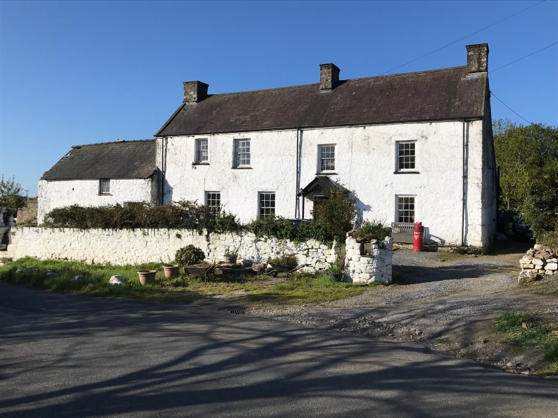
Tyle House farmhouse was probably built in the C17, the original part being the southern half of the front range. There was a door in the south gable beside a large fireplace, serving the hall; an inner room to the north had a smaller gable-fireplace. This original part is undatable; its original chamber floor and roof do not survive to provide clues. The stone outshut-stairs in its rear wall survive. An agricultural range later added to the south incorporates an entrance cross passage.
This early farmhouse was raised in status in the C18. It was enlarged by the addition of the north half of the present front range plus, a little later, a lean-to range at the rear. The old house was heightened to agree with the new construction. As enlarged the house has a nearly-central main door and stairs. This enlargement, at least of the front range, had taken place by 1786. The work was perhaps performed piecemeal, as regular fenestration was not achieved. The enlargement may be associated with the occupant Richard Gordon, who was Sheriff of Glamorgan in the year 1770. In 1844 the house was the farmhouse of a tenancy of about 130 acres in the Penrice estate.
The house was again considerably enlarged in the late C19 (post-1878), by the addition of a rear wing including kitchens, the wing being given a giant-dormered front facing the garden to the south side of the house.
A large farmhouse of two storeys with a front elevation of four windows, facing east to the road, with a partly collapsed lofted farm range in tandem to the left. Local stone, whitened. Slate roof with tile ridge; large kitchen chimney to left, ordinary mid and right-end chimneys, all stacks in stone. Rendered left gable with small attic window. The rear span of the main range is partially roofed in artificial slates.
The front fenestration is curiously irregular. The four windows of the left half of the front elevation (the original house with its later upper storey) are all replaced 12-pane horned-sash windows; the frame of the larger upstairs window is exposed, the others recessed. In the right half of the house the upper windows are of 12 panes, with original C18 hornless sashes; the lower window is modern. Slate sills throughout. Modern boarded door, modern porch.
The interior retains two important features: the kitchen fireplace with its back to the south gable wall, and entrance to one side, retaining its timber bressummer and small bread oven, and the adjacent winding stone outshut stairs.
When inspected (1999) the original end entrance doorway in the south gable wall was in process of being re-opened.
A vernacular farmhouse retaining its original end-entry and stone stairs in outshut, gaining character from the manner in which it was improved in the C18.
External links are from the relevant listing authority and, where applicable, Wikidata. Wikidata IDs may be related buildings as well as this specific building. If you want to add or update a link, you will need to do so by editing the Wikidata entry.


Other nearby listed buildings
