History in Structure

Milestone

A Grade II Listed Building in Llanllechid, Gwynedd

More Photos »
Approximate Location Map
Large Map »

Coordinates

Latitude: 53.1651 / 53°9'54"N

Longitude: -4.0474 / 4°2'50"W

OS Eastings: 263222

OS Northings: 365069

OS Grid: SH632650

Mapcode National: GBR 5T.4M8X

Mapcode Global: WH54G.SPVX

Plus Code: 9C5Q5X83+22

Entry Name: Milestone

Listing Date: 9 March 2000

Last Amended: 9 March 2000

Grade: II

Source: Cadw

Source ID: 22921

Building Class: Transport

ID on this website: 300022921

Location: Situated close to the track to Plas Penisarnant off the A 5 south of Bethesda; set directly on road abutting rubblestone boundary wall.

County: Gwynedd

Town: Bethesda

Community: Llanllechid

Community: Llanllechid

Locality: Braichmelyn

Traditional County: Caernarfonshire

Tagged with: Milestone

Find accommodation in
Bethesda

History

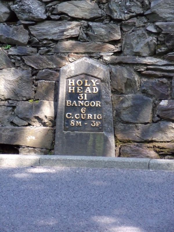
Following the Act of Union in 1801, a programme to improve the roads between the two capital cities of London and Dublin was initiated. In 1811 Thomas Telford was commissioned to undertake a survey of the roads between London and Holyhead and in 1817 began work on the northern stretch of the road at Shrewsbury. As well as overseeing the work, Thomas Telford also designed every detail of the road, and this milestone is one of a number designed for it. Milestones between Bangor and Cernioge were erected in the period between 1825 and February 1827.

Exterior

Dressed Anglesey limestone slab, with shallow triangular head and raking chamfered sides. Cast iron inset plate, white lettering on black reading: HOLY- / HEAD / 31 / BANGOR / 6 / C. CURIG / 8M – 3F. Some damage to stone to right of cast-iron plate.

Reasons for Listing

Listed as a fine example of one of Telford's milestones retaining its cast iron plate.

External Links

External links are from the relevant listing authority and, where applicable, Wikidata. Wikidata IDs may be related buildings as well as this specific building. If you want to add or update a link, you will need to do so by editing the Wikidata entry.

Recommended Books

Other nearby listed buildings

  • II* Plas Penisarnant
    At the foot of Nant Ffrancon, between the A5 and the river Ogwen, in wooded grounds.
  • II Outbuildings at Ceunant
    One outbuilding situated on main approach to cottages, other straddling southern boundary of left cottage.
  • II Slate fencing, rubblestone walling and privies at Ceunant
    Slate fencing and rubblestone walling defining boundaries of Ceunant; privies in cottage gardens.
  • II Ceunant
    Situated in remote position at end of short rough track running off the road directly to the north-east of Pont y Ceunant; there is a steep drop immediately to the west of the rear gardens of the cott
  • II Pont Ogwen (partly in Llandygai community)
    Spanning the Afon Ogwen immediately to the south-west of the A 5 at the entrance to the Ogwen Bank Caravan Park; carries a track over the river skirting the eastern side of the Penrhyn Slate Quarry.
  • II Pont Ogwen (partly in Llanllechid community)
    Spanning the Afon Ogwen immediately to the south-west of the A 5 at the entrance to the Ogwen Bank Caravan Park; carries a track over the river skirting the eastern side of the Penrhyn Slate Quarry.
  • II Pont y Ceunant (partly in Llanllechid community)
    Spanning the Afon Ogwen near the point where the minor road through Nant Ffrancon meets the A 5 at Tyn-y-maes.
  • II Pont y Ceunant (partly in Llandygai community)
    Spanning the Afon Ogwen near the point where the minor road through Nant Ffrancon meets the A 5 at Tyn-y-maes.

BritishListedBuildings.co.uk is an independent online resource and is not associated with any government department. All government data published here is used under licence. Please do not contact BritishListedBuildings.co.uk for any queries related to any individual listed building, planning permission related to listed buildings or the listing process itself.

British Listed Buildings is a Good Stuff website.