Latitude: 52.6468 / 52°38'48"N
Longitude: -3.96 / 3°57'36"W
OS Eastings: 267490
OS Northings: 307256
OS Grid: SH674072
Mapcode National: GBR 8X.6CMD
Mapcode Global: WH571.4QJR
Plus Code: 9C4RJ2WQ+PX
Entry Name: Pen-y-garreg
Listing Date: 10 April 2000
Last Amended: 10 April 2000
Grade: II
Source: Cadw
Source ID: 23196
Building Class: Domestic
ID on this website: 300023196
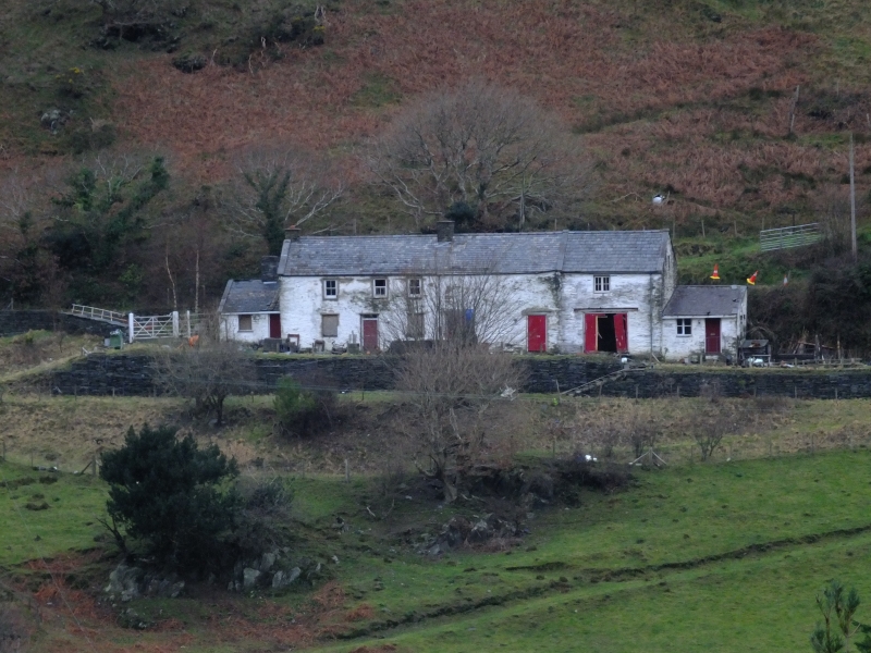
Location: The farmhouse is located on the steep hillside facing S over the village, and is reached by a contoured road off the Llanegrin Road to the rear.
County: Gwynedd
Town: Tywyn
Community: Llanfihangel-y-Pennant
Community: Llanfihangel-y-Pennant
Locality: Abergynolwyn
Traditional County: Merionethshire
Tagged with: Farmhouse
Built in the C18 or early C19.
Farmhouse with farm buildings set in line. The house is built of slate rubble, and whitewashed, with an old irregular shaped slate roof to the house, and continued in modern slate over the former farm building in line. Slate coped gables and blue clayware ridges. Two storeys, the house of 2 bays, parlour on the left and kitchen to the right. Symmetrical front with a central boarded door with a narrow overlight, and late C19 4-pane sash windows each side, and one above the door on the first floor. Gable stacks. The accommodation is extended into the former farm building attached in line to the E. This is of one storey and attic. Two stable-type doors in the front wall which has been largely rebuilt in concrete blockwork. Loft access from the rear. At the W gable end an added stone and slated lean-to former washhouse with a stone stack on the rear wall. Boarded door and timber window.
Not accessible at the time of inspection.
Included as a building of traditional form and materials, in a conspicuous location overlooking the village.
External links are from the relevant listing authority and, where applicable, Wikidata. Wikidata IDs may be related buildings as well as this specific building. If you want to add or update a link, you will need to do so by editing the Wikidata entry.


Other nearby listed buildings