Approximate Location Map
Large Map »
Latitude: 51.6404 / 51°38'25"N
Longitude: -3.8043 / 3°48'15"W
OS Eastings: 275243
OS Northings: 195051
OS Grid: SS752950
Mapcode National: GBR H2.7ZT1
Mapcode Global: VH5GV.01P9
Plus Code: 9C3RJ5RW+57
Entry Name: Ynysmaerdy Incline bridge over Pant Howel Ddu
Listing Date: 19 May 2000
Last Amended: 19 May 2000
Grade: II
Source: Cadw
Source ID: 23303
Building Class: Industrial
ID on this website: 300023303
Location: Crossing a minor road to Pant Howel Ddu Farm approximately 1.1km NE of St Clement's church.
County: Neath Port Talbot
Community: Briton Ferry (Llansawel)
Community: Briton Ferry
Locality: Pant Howel Ddu
Traditional County: Glamorgan
Tagged with: Bridge Railway bridge
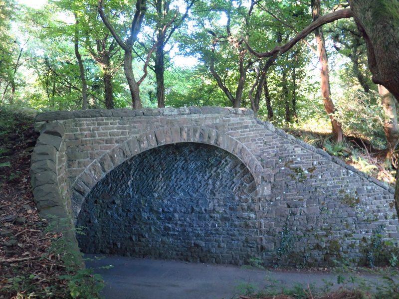
The South Wales Mineral Railway was incorporated in 1853 for a 13-mile cross-country line from the collieries at Glyncorrwg to the docks at Briton Ferry. The route was laid out by Isambard Kingdom Brunel, who was later succeeded by R.P. Brereton. At the Briton Ferry end a double-tracked cable-worked incline 1.5 miles long was required to overcome the steep terrain. The railway opened in 1861 from Briton Ferry to Tonmawr and to Glyncorrwg in 1863. Originally broad gauge, it was converted to standard gauge in 1872. The railway incline was an antiquated concept by the mid C19 and was expensive to operate. The railway was never a financial success, partly due to the vicissitudes of colliery companies in Glyncorrwg who operated the line. In 1908 the line was taken over by the Great Western Railway, who closed the incline in 1910.
A deep single-span bridge of snecked, rock-faced sandstone and a round arch with tooled voussoirs. The arch is set at an angle to the road. Its side walls are battered, giving a horseshoe-shaped profile to the bridge. The battered abutments retaining the embankment are built at oblique angles to the bridge and are ramped down to ground level. The bridge and abutments have rock-faced copings. There is no parapet.
Listed for industrial archaeological interest as a mid C19 railway bridge designed by the office of one of Britain's most influential engineers.
Scheduled Ancient Monument Gm 489.
External links are from the relevant listing authority and, where applicable, Wikidata. Wikidata IDs may be related buildings as well as this specific building. If you want to add or update a link, you will need to do so by editing the Wikidata entry.


Other nearby listed buildings
